OUR VISION
The world's finest educators supporting science, technology, engineering, and math (STEM) learning for pre-kindergarten to post-graduate students using real-world applications from satellites and satellite data.
OUR MISSION
To enhance the education environment to excite students about science, technology, engineering, and math through space-based technology -- satellites and satellite data.

Whoopi Goldberg

Remember this: They hate you because you represent something they feel they don't have. It really isn't about you. It is about the hatred they have for themselves. So smile today because there is something you are doing right that has a lot of people thiking about you.
Shannon Alder

TABLE OF CONTENTS
Click a RED link to view article
Association News
Input from Ron
John's Journey
Satellites with Ed
News from NASA
Go to SEA Home Page

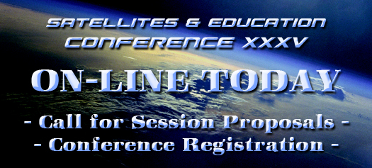
On-line conference registration is now open. Visit https://SatEd.org/conferences/ today. Mark your calendars now for the 35th annual Satellites & Education Conference to be held Friday-Saturday, July 29-30, 2022 at California State University, Los Angeles. This year, the conference will feature a hybrid format where registered attendees will be welcomed in-person as well as on ZOOM. Plans for the conference are underway. Watch this space for announcements of keynote speakers and relevant cuncurrent sessions.
The goal of the Satellites & Education Conference is raising the level of awareness, in teachers and students grades K-12 and beyond, of the availability and use of satellite-based remote-sensing data and related engineering and technology opportunities and thereby fostering informed stewardship of our planet, its resources and inhabitants. For more than three decades, the annual Satellites & Education Conference has brought teachers and students together with resource-rich representatives of academia, the aerospace industry, and government - especially NOAA, NASA, USGS - providing knowledge and tools to address the challenges of 21st century STEM education.
This outstanding event for teachers has been offered each and every year since 1988. From 1988-2001, the conference was held at West Chester University in Pennsylvania. The conference has been hosted by Cal State LA since 2002.
Teachers attending the Satellites & Education Conference continuously report this is the best conference they ever attended. It is rare to find such a rich community of scientists and engineers from aerospace, NOAA, NASA, USGS, and university researchers interfacing so supportively with educators!
Don't miss the event of the summer celebrating 35 years of service and community in support of STEM education and an awareness of ever-changing global climate. Register at https://SatEd.org/conferences/ today!
(And did we mention Active Members of the Satellite Educators Association automatically receive a 23% discount on conference registration? Not a member yet? Or has your membership lapsed? No problem. Just include membership with your conference registration to receive the discount.)

[ Back to Top ]
Start planning now! Satellites & Education Conference XXXV, July 29-30, 2022, needs presenters and exhibitors for both the face-to-face conference at Cal State LA and on ZOOM!
Presenters can submit presentation proposals and exhibitors can request exhibit space -- all online.
Of particular interest are presentations and exhibits about or that include the James Webb Space Telescope.
Some may be asking how it is possible to exhibit on ZOOM for an in-person conference. There are pros and cons for both modes of presentation and exhibit. Check out the detailed information about benefits for presenters and exhibitors, co-presenters, co-exhibitors, facilities, handout distribution, and more at the links above. It's all available on-line now.
Below you will find links to the Conference Highlights pages of the last five Satellites & Education Conferences -- two were in-person (pre-COVID) and two were completely on-line. Peruse the pages and their downloadable Conference Programs at your convenience to get an idea of the type and quality of the presentations and exhibits that happen at Satellites & Education Conferences. Then consider how best to share your information.
Thank you in advance for supporting "Satellites & Education."
[ Back to Top ]
Still undecided about signing up for Satellites & Education Conference XXXV? Want to know what you are signing up for?
Watch https://SatEd.org/conferences/ for latest details about speakers, presenters, and exhibitors when the conference program is announced.
Take a look at these Conference Highlights pages and their downloadable Conference Programs from the last five years -- three from in-person conferences (pre-COVID) and the last two were on-line only. Each conference was extraordinary in its own way. Perusing the programs may give you as sense of the type and quality of happenings at Satellites and Education Conferences.
Then visit SEA's Conference home page to join us in person or on ZOOM for the 35th annual Satellites & Education Conference!
[ Back to Top ]


By Ron Gird, Meteorologist and former Satellite/Spaceflight and Outreach Program Manager for the National Weather Service
This story from NASA Science highlights the development of a new instrument to enhance our understanding the interelationships of clouds, weather, and climate. An interview with William Deal, staff engineer at Northrup Grumman Systems Corporation tells about SMICES (Smart Ice Cloud Sensing). Enjoy
From NSAS Science
With support from NASA’s Earth Science Technology Office (ESTO), a team of researchers is developing a new instrument that will help scientists better understand the impact high-altitude ice clouds have on weather and climate change on Earth.
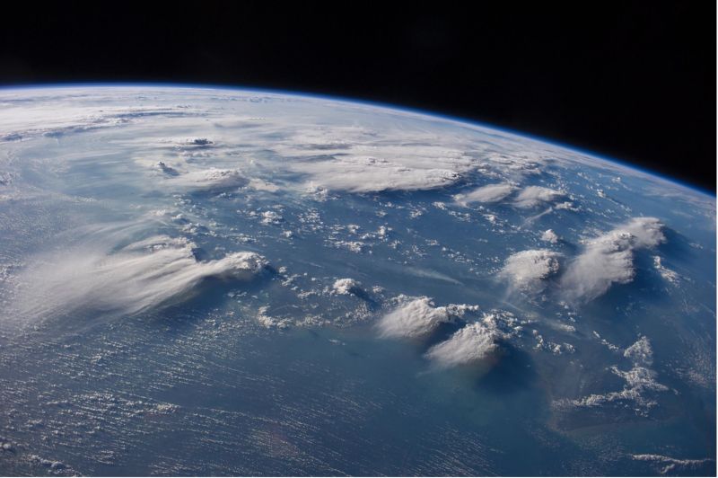
Wispy white cirrus clouds stretched across a blue sky may seem insubstantial, but they actually have a huge impact on Earth’s climate. Learning more about these clouds would allow scientists to develop better models for understanding storms and climate change. “Cirrus clouds cover more than 50% of our planet. If we can build a better body of fundamental data describing the structure of these clouds, we’ll have a far superior understanding of how that coverage will affect our weather and climate moving forward,” said William Deal, a staff engineer at Northrop Grumman Systems Corporation.
[ Back to Top ]

By John D. Moore, Executive Director, Institute for Earth Obervations at Palmyra Cove, New Jersey
In every community in which we regularly participate, new opportunities for teachers, students, educators seem to emerge regularly. It seems like some new opportunities simply come to you, while others must be actively sought out. In reflecting on my own journey, I think I can safely say that none of it was based on a random encounter. When in the classroom, I taught my students that “one thing does lead to another.” I say this to preface a statement of concern about how STEM education today seems to be all over the place. Unfortunately, this is not a new occurrence in educational policy in this country. How often in the past have great new initiatives been rolled out only to get watered down and disappear over time. Disappear because there were no clear goals or someone else came up with “the next best thing” in replacement. This ineffective “process” impacts us. I’m not talking about impacts on curriculum or instructional strategies. I am talking about impacts on why STEM was elevated to a national priority: America’s ability to compete in a global atmosphere, the impact on the economy and our national security. Looking at that bigger picture, good high paying jobs for the next generation of students are an important by-product, but not the main driver of a more “effective process.” For more effective example, look at what SEA has provided for decades challenging the system, developing pathways where none existed, and bringing authentic STEM applications around the world, all while introducing students to unique options of study most students and teachers never hear about. It’s time for a change. It’s time to bring what SEA does for students into the fore.
The need for strong STEM education jumped into sharp relief for me last month when my journey brought a new, and rather special, opportunity. I was honored to be inducted as an “Honorary Commander” at Joint Base McGuire-Dix-Lakehurst in New Jersey. I was paired with LTC Maryann Karlen, commander of the AMC-Test and Evaluation Squadron. It is a humbling and fantastic experience getting to meet with these exceptional women and men and begin to learn about their individual responsibilities. The importance of acting as a team was expressed to me emphatically and often. The most significant take-away, however, was a message communicated by most individuals I met: the importance of STEM education and the critical place it holds in America’s future.
As a quick introduction, the Air Mobility Command Test and Evaluation Squadron (AMC TES) is AMC’s sole Operational Test and Evaluation (OT&E) organization. It is charged with the testing and evaluating AMC’s airlift and tanker weapon systems, new or improved subsystems being considered for integration into these systems, and the full range of ground support equipment to support AMC’s global mission. The dedication and institutional knowledge of its personnel are what empower AMC TES to identify improvements to modernization programs. (loosely captured from www.jbmdl.jb.mil)
As the relationship with AMC-TES grows, I will bring you updates in future John’s Journey. At this point, any day that I can be around airplanes and talk about flying is a great day for me!

Another opportunity presents itself. In last month’s John’s Journey, I wrote about Sriram Elango’s Congressional App award. Congressman Kim will visit the Institute for Earth Observations soon to recognize Sriram. You can be sure the congressman will get an in-depth introduction to the value of satellites in education. Hopefully, the event will produce a stronger advocate for all of our collective work in SEA. Remember to look for the National Level Ceremony this month. If Sriram gets more recognition, it will not only honor him, but it will get the message of satellites in education before a larger audience.
In other news, our paper about the A3Sat Enterprise was accepted for presentation in the K12 educational poster session at the SmallSat Conference. The SmallSat Conference is regarded as one of the premier conferences for all things CubeSat. I will join colleagues Dr. Jin Kang and Kevin Simmons as we continue to show the values of students working with CubeSats at all levels of education.
The GLOBE Annual Meeting will be virtual one again this year. Call for proposals and registration information are available on GLOBE’s website (www.globe.gov) Look for our friend and SEA colleague Peter Falcon to be there representing JPL and his great work within GLOBE community.
Working directly with Merge Technologies, a new version of HoloGLOBE is due to be released soon that will be even more robust. Merge Technologies has a strong commitment to education and has provided key support to reactivate this project. A sincere shot-out to Franklin Lyons, founder, for providing the resources to get HoloGLOBE back up and running.
For future John’s Journey articles, there are some other cool developments underway I would classify as “Back to the Future” like building antennas to capture satellite direct read-out imagery in the classroom. (“Back to the Future” because that was one of Helen Martin's classroom activities that led to the first Satellites & Education Conference in 1988.) Some might ask why? My answer … why not? SEA has decades of evidence and answers to that question.
Remember - “you can teach anything with satellites”.
Stay safe - stay well!
For now, I'm John...and this is my journey.
[ Back to Top ]

By Edward Murashie, President, Proengineered Solutions
A longtime friend of mine called me up the other day and asked if he should take down the 12’ dish antenna mounted on top of his home. Living in Florida, he was concerned about hurricanes “wrapping the dish around his home”.
First a little background. Steve directly received GOES-13 weather satellite transmissions for over 30 years as a hobby and for planning boating outings. At the end of 2017, GOES-13 was replaced by next generation GOES-16 with a new transmission format, rendering his equipment useless. He could install a new receiver and computer software, but should he?
To understand why I am telling you this story, let’s look at the exact opposite question. Suppose Steve had asked, “Ed should I put up an antenna and assemble a weather satellite receiving station at home or in the classroom?” Suppose further his next questions were, “What type of station” (because there are different types of satellites), and, “What could I get directly from a satellite that I could not get online.” My answer to all three questions would be, “What do you want the data for, and what do want to learn?”
One place to start learning about satellites is on the SEA’s website, “Using Satellites in Education” at https://SatEd.org/satellites.htm. There you will find five chapters on many aspects of weather satellites including gathering and analyzing data.
As for online image data, in addition to the those listed in “Using Satellites in Education, consider these. If you want street maps or satellite images with a reasonable resolution, you probably already know about Google Maps at https://www.google.com/maps. You probably also know about the satellite image layer and how you can drop the stick figure man onto the map for a street view of the drop location. But did you also know that if you click on the clock icon in the upper left box in the street view you can select street images taken in past years? You can find similar views with the download version of Google Earth at https://www.google.com/earth/versions/#download-pro. A tutorial lesson plan using Google Earth to study land change over time is available in the SEA Lesson Library (https://localhost/SatEd.org/library/search.htm). Have you seen ZOOM Earth at https://zoom.earth/? Zoomed out you will see the latest weather satellite image and as you zoom in you can get a similar resolution as Google Maps. The satellite image data is from a different source and usually newer. You don’t have the street view option, but you have a wind animation, wildfire information, and you can use the tools to measure distances and areas.
If you want to see or download the latest cloud images over North or South America, you will probably want images from the National Oceanic and Atmospheric Administration’s (NOAA) Geostationary Operational Environmental Satellite (GOES). One of the best online resources can be found at NOAA’s GOES Image Viewer at https://www.star.nesdis.noaa.gov/goes/index.php. It is also the best place to find animations of the latest geostationary satellite imagery as explained in the February 2022 newsletter found at https://SatEd.org/newsletters/Newsletter-202202.htm.
Around the globe other countries operate additional geostationary weather satellites and their images are also available online:
If you want to study land features of higher resolution than GOES, one good source is Landsat data. https://earthexplorer.usgs.gov/ is one of the best sources of Landsat data and a tutorial can be found in the last newsletter. USGS also offers the Global Visualization Viewer (GloVis) at https://glovis.usgs.gov/. A tutorial lesson plan for using GloVis is available in the SEA Lesson Library at https://localhost/SatEd.org/library/search.htm or More Lessons from the Sky in last month's SEA Newsletter. For satellite data used to study a wide range of Earth sciences, one of the largest collections is NASA’s Earth Data found on their website https://earthdata.nasa.gov/learn/getting-started.
Up until now, you would not have to assemble a satellite ground station because of all the online resources. But let’s say your needs are to not only look at weather images or study land sciences, but to teach other STEM (Science Technology Engineering Math) elements. Or you have students who want to explore STEM outside of the classroom, have an upcoming science fair, or want to earn some extra credit.
You or the students are probably not going to want to spend too much money. So that will exclude the $1M+ Landsat and $20K+ GOES highest resolution (GRB) ground stations. But for about $200 plus the cost of a computer you can assemble a GOES low resolution (HRIT) ground station. Nooelec has assembled all the parts and sells it on Amazon, just search for Nooelec GOES Weather Satellite Bundle. For more information try these:
So what did I tell my friend Steve? It is probably best to take your antenna down and enjoy the online images. Just like Steve, if you have questions about satellites please feel free to contact me at eamurashie at gmail dot com.
[ Back to Top ]

From NOAA National Environmental Satellite Data and Information Serevice
March 14, 2022
On March 14, 2022, GOES-T executed its final engine burn, placing the satellite in geostationary orbit 22,236 miles above Earth. Upon reaching this milestone, GOES-T was renamed GOES-18. GOES satellites are designated with a letter prior to launch and a number once they achieve geostationary orbit.
NOAA’s GOES-T satellite launched on March 1, 2022, at 4:38 p.m. EST, lifting off from Cape Canaveral Space Force Station in Florida. The satellite launched aboard a United Launch Alliance Atlas V rocket from Space Launch Complex 41. The launch was managed by NASA’s Launch Services Program, based at Kennedy Space Center.
GOES-T separated from the Atlas V Centaur upper stage at 8:11 p.m. EST on March 1. GOES-T mission managers confirmed that its solar arrays successfully deployed at 8:28 p.m. EST and the satellite was operating on its own power.
The launch vehicle delivered GOES-T to a geostationary transfer orbit, a highly elliptical orbit where the satellite is close to the Earth during one part of its orbit and far from the Earth on the opposite side. Placing GOES-T in a geostationary transfer orbit provides the satellite a path to reach its final geostationary orbit over the equator (see diagram below). After a series of orbit-raising maneuvers and engine burns, on March 14, GOES-T was delivered into a circular geostationary orbit. The satellite is now in position to orbit at the same rate Earth rotates, so it can keep constant watch over the same region.
[ Back to Top ]


By Adam Voiland, NASA Earth Observatory
January 11, 2022
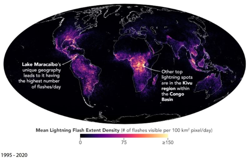
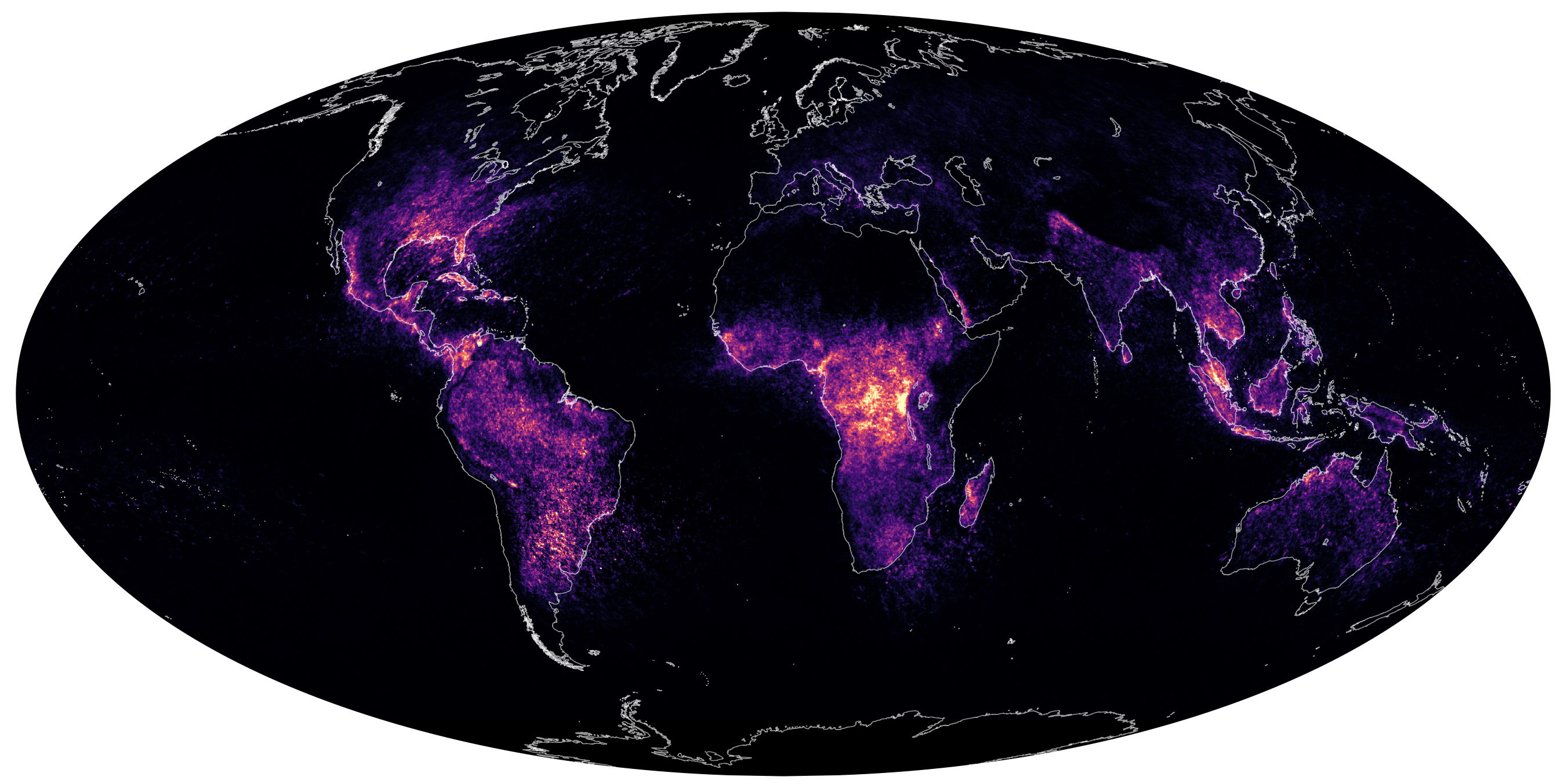
Since the dawn of humanity, lightning has been a source of both curiosity and awe. Though dozens of flashes are crackling at any moment somewhere on Earth, these brief electrical discharges—typically lasting less 30 microseconds—remain unusually challenging to study.
However, satellites have done much to deepen our understanding of lightning in recent decades. Sensors in space have provided high-quality observations of lightning flashes since the 1990s, making it possible for atmospheric scientists to quantify and map the global distribution of lightning.
One of the first global maps of lightning activity was published in 2001 with data from the Optical Transient Detector (OTD) on the commercial OrbView-1 satellite and the Lightning Image Sensor (LIS) on NASA’s TRMM satellite. Two decades later, a second LIS mounted on the International Space Station (ISS) is adding to long-term records and making newer, better maps of global lightning activity.
[ Back to Top ]


By Andrea Shea, Wbur
February 25, 2022
It's safe to say we New Englanders have a love-hate relationship with snow. A winter storm's freshly-falling beauty can inspire childlike wonder — until we have to dig out our cars and shovel the sidewalks.
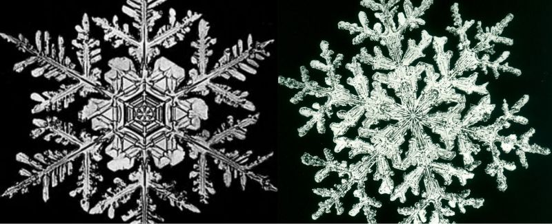
But for Wilson "Snowflake" Bentley, a self-taught, 19th-century photographer, snow drove a deep fascination that forged a lasting legacy.
The Vermont farmer is credited with creating the world's first clear images of snow crystals. He was born in the perfect place: Jericho, about 12 miles east of Burlington. The town is in the heart of the state's snowbelt and gets 100-plus inches of white stuff each winter.
“This was the time of year that he loved more than anything,” Bentley's great-grandniece, Sue Richardson, said as she crunched along a path near the center of this one-stoplight town. “While the rest of the farmers were cursing it and saying, 'Oh, I can't wait for summer,' Willie was in his glory.”
Richardson — a seventh-generation Bentley — is caretaker of her great-granduncle's legacy. She said he lived on the family's dairy farm where, for over four decades, he captured more than 5,000 unique snow crystals.
[ Back to Top ]
From NOAA Education
March 22, 2022
It's officially spring in the Northern Hemisphere and NOAA is here to celebrate! From new graphics to educational resources, spring into science with us and check out our content.
[ Back to Top ]
Share your satellite-based lesson ideas with the teaching comunity.
Send us a full lesson plan, or simply suggest a lesson idea. If you found the idea online, please share the source as well. The lesson can be about anything that helps connect learners with satellite-based technology - any grade level K-12 - any STEM subject area or geography.
"Satellite-technology" includes any part of the science, math, engineering, or technology of satellites, rockets, and remote sensing instruments as well as the use of any environmental satellite data to explore questions related to aspects of global change and local impacts in the long term, short term, and catastrophic time frames. Of special interest are lessons providing oppotunities for learners to inquire, experiment, and apply mathematics.
Perhaps you designed a lesson yourself - we will happily prepare it for future publication in More Lessons from the Sky and inclusion in the SEA Lesson Plan Library. Perhaps you found a worthy lesson plan published elsewhere - we can research it inclusion in a lesson plan spotlight. In either case, you will receive full credit for developing and/or brining theless to the attendtion of the teaching community. Don't forget to share your insights if you tried the lesson with students.
Send your ideas to SEA.Lessons@SatEd.org.
[ Back to Top ]
![]()
This edition of the SEA Newsletter was produced in HTML5.
It is best viewed with most recent updates of Firefox, Edge, Chrome, Opera, or Safari.
©Satellite Educators Association, Inc. https://SatEd.org SEA.Newsletter@SatEd.org
Satellite Educators Association, Inc. is a 501(c)(3) non-profit educational organization.
The SEA Newsletter is published on-line monthly except January and August and available at no cost.
SEA terms, conditions, policies, ansd contact information are detailed HERE.
Unless otherwise listed, all photo and image credits are the authors of the articles.
Any opinons expressed in this Newsletter are those of the authors
and not necessarily those of the Satellite Educators Association, Inc.
or any of its officers, members, or representatives.
Many SEA Newsletter items contain third-party links to sites not governed by Satellite
Educators Association, Inc. The viewer is cautioned to be aware of the terms of use and
privacy policies for those third-party sites.![]()