
OUR VISION
The world's finest educators supporting science, technology, engineering, and math (STEM) learning for pre-kindergarten to post-graduate students using real-world applications from satellites and satellite data.
OUR MISSION
To enhance the education environment to excite students about science, technology, engineering, and math through space-based technology -- satellites and satellite data.

Søren Kierkegaard

The most important kind of freedom is to be what you really are. You trade in your reality for a role. You trade in your sense for an act. You give up your ability to feel, and in exchange, put on a mask. There can't be any large-scale revolution until there's a personal revolution, on an individual level. It's got to happen inside first.
Jim Morrison

TABLE OF CONTENTS
Click a RED link to view article
Satellites & Education Conference XXXV
Input from Ron
John's Journey
News from NASA
More Lessons
from the Sky
Go to SEA Home Page

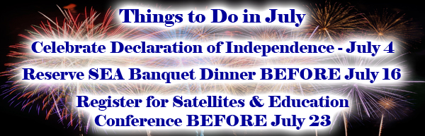
Join us for the 35th annual Satellites & Education Conference on Friday & Saturday, July 29-30, 2021. Featuring a hybrid format this year, the conference will be held both in-person at California State University, Los Angeles, and on ZOOM with presenters and exhibitors in both arenas.
Produced by the Satellite Educators Association, Inc., the conference is hosted by the Charter College of Education at Cal State LA (since 2002), and supported by both NASA and NOAA. Presenters and exhibitors will deliver content both in-person and on ZOOM, all from Cal State LA's Golden Eagle Ballroom. Registration includes breakfast and lunch offerings both Friday and Saturday and full access to our unique Exhibit Hall (also in the Golden Eagle Ballroom).
What is Satellites & Education? So much of what we know about this Earth, our "island home," and our place in it comes from robotic spacecraft with remote sensors orbiting the Earth and traveling to other worlds. The scientific discoveries, the careful engineering, the creative technologies, all employing a mathematical language -- spectacular and awesome advances with additional applications in many other fields of human endeavor. Yet so few teachers and students truly know about them and their importance to life today and in the future. The Satellite Educators Association, Inc. (SEA) was founded in 1989 in response to an overwhelmingly positive turn out for the first Satellites & Education Conference. SEA is a professional organization of educators and those who want to enhance the education environement to excite students about science, technology, engineering and mathematics (STEM) through space-based technology -- satellites and satellite remote-sensing data. SEA was founded by a teacher with a vision. Today, teachers comprise more than half of the Executive Committee and Advisory Board.
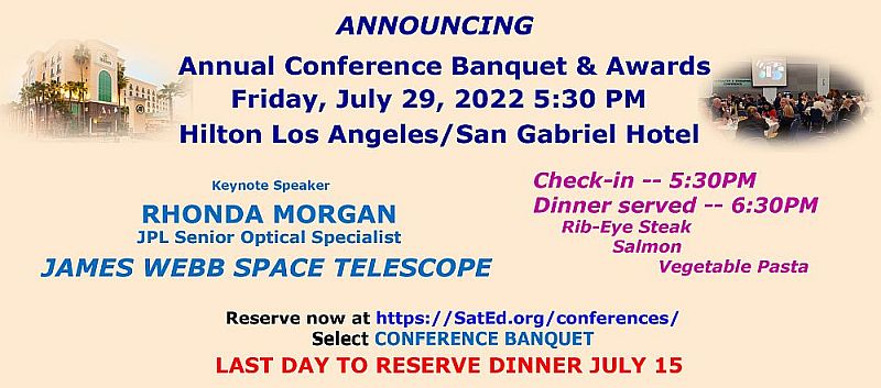
Satellites & Education Conference XXXV begins with continental breakfast at 8:00AM Friday, July 29 and officially opens at 8:45. The last session will end about 4:30PM allowing plenty of time to move to the Hilton San Gabriel Hotel for the Annual SEA Banquet and Awards Program. Banquet check-in opens at 5:30PM with dinner served at 6:30PM and a complete update on the James Webb Space Telescope from the keynote speaker. Back at the Golden Eagle on Saturday, continental breakfast is available at 8:00AM, and the first session starts at 9:00AM. The Conference Closing session will finish about 3:00PM and the Exhibit Hall will close at 3:30.
Due to COVID protocols still in place at Cal State LA, the banquet will be off campus at the Hilton Los Angeles/San Gabriel Hotel. More information about the banquet, the hotel, driving directions and maps, are available HERE. Select Conference Banquet or Travel Tips. The banquet entreé selections include rib-eye steak, salmon, and vegetable pasta. Banquet tickets can be purchased HERE (select Conference Banquet). Our amazing friends at AIAA will enjoy an automatic 10% discount on dinner tickets. Hurry -- the last day to order dinner is July 15.
Registration for the conference is just $65. The last day to register for the conference is July 22. Pre-registration online is required this year.
Informative keynote speakers -- sensational sessions -- extraordinary exhibits -- this is a conference not to be missed!
Scroll down to preview Satellites & Education Conference XXXV.....

[ Back to Top ]

Scientists are almost certain a vast ocean lies beneath Europa’s icy shell. NASA's Europa Clipper spacecraft will perform dozens of close flybys of Jupiter’s moon Europa, gathering detailed measurements to investigate whether the moon could have conditions suitable for life. Europa Clipper is not a life detection mission – its main science goal is to determine whether there are places below Europa’s surface that could support life.
Our speaker, Dave, led real-time flight operations (aka “Mission Control”) for the 20-year, multinational Cassini-Huygens Mission in the Saturn system; it ended in 2017. Among Cassini’s many discoveries was that Saturn’s tiny moon Enceladus turned out to be yet another promising ocean world here in our own solar system. Dave will talk about how Europa Clipper will be conducting a thorough reconnaissance of Jupiter’s ocean world Europa, “Merely half as far away, exploring Europa offers its own set of challenges.”
The spacecraft, in orbit around Jupiter, will make nearly 50 flybys of Europa at closest-approach altitudes as low as 16 miles (25 kilometers) above the surface, soaring over a different location during each flyby to scan nearly the entire moon. Europa Clipper will launch in October 2024 and will follow a Mars-Earth Gravity Assist (MEGA) trajectory. The spacecraft will travel for five and half years and arrive at Jupiter in April 2030. The Europa Clipper is NASA’s largest planetary mission spacecraft. With its massive solar arrays and radar antennas, Europa Clipper will be the largest spacecraft NASA has ever developed for a planetary mission. The spacecraft needs large solar arrays to collect enough light for its power needs as it operates in the Jupiter system, which is more than five times as far from the Sun as Earth.
The James Webb Space Telescope (JSWT) is the largest and most complex space telescope NASA has built. The telescope will see the first galaxies forming, will peer through dust to see the birth of planets and stars, and will examine exoplanet atmospheres. The telescope has a 6.5-meter diameter mirror comprised of 18 hexagonal segments and a tennis court size sun shield that keeps the telescope cold at 35 degrees Kelvin. JSWT had 50 major deployments involving the release of 178 pins. The six-month commissioning phase encompassed more than a thousand procedures to align the mirror segments and to verify the 17 instrument modes. The science observations begun in July are a culmination of twenty years of international effort led by NASA. What does it take to achieve this level of optical performance? And how will it be improved by two orders of magnitude for the next 6-meter space telescope that is just starting its twenty-year journey to launch? Extreme optical performance will be required to search for earth-size exoplanets around nearby stars and to take spectra of those exoplanets to look for biosignatures. The lessons and experience of building JWST move us closer to being able to build a telescope to look for Earth 2.0.
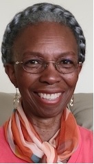
Dr. Morgan earned her MS and PhD in Optical Sciences at the University of Arizona with an emphasis in nulling interferometry for exoplanet direct imaging, and her Bachelor’s in Electrical Engineering from Caltech with an emphasis in remote sensing. She has more than 20 years of experience at JPL, the last seven in the Exoplanet Exploration Program Office as the HabEx large concept study Technologist and as lead of the multi-institutional yield Exoplanet Science-performance Evaluation Team. She has worked extensively with the JPL astrophysics community in various capacities, from proposal work to program and project work, to develop technologies and missions to search for Earth 2.0 and increase our understanding of the universe.
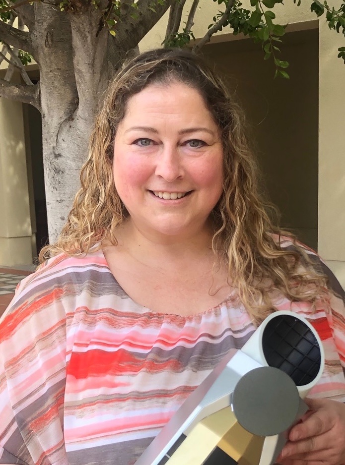
Dr. Shannon holds a BA and MS in Biology and an EdD in Learning and Instruction, Science Education. She recently retired as Director of STEM Education at Synergy Academies. She was the founding principal of Synergy Quantum Academy.
Dr. Shannon will show us how to make better use of the resources discovered this weekend in order to achieve greater results.
[ Back to Top ]

| Project Nieuwestad: Modeling Exoplanet Habitability with Machine Learning Luke Meir, Ishaan Agrawal, High School Students Winners of the Northwest Science Expo (Washington, Oregon, Idaho) |
| As advancements in space exploration and astronomy have increased dramatically in recent decades, looking to humanity’s future in an extraterrestrial or even an extrasolar context is gradually emerging from science fiction into science fact. Additionally, the pervasive question of “are we alone in the universe?” has driven much data collection on observable exoplanets. Thus, the collection, cataloging, and organization of these planets in the context of habitability is an important field of work within astrophysical research. While these are barely even a measurable percentage of what’s out there, impressive thousands of exoplanets have been observed and catalogued. Models and their features in a relevant context present an important question with constantly evolving answers. Our research aims to combine machine learning and exoplanet databases to model the prospective habitability of these observed exoplanets. In our model construction, we trained a machine-learning algorithm to identify the most important features that make a planet habitable and to identify whether or not a planet is habitable. |
| Classroom Activities with the AMSAT Functional CubeSat Simulator Frederic Raab, Educator College of the Desert |
| In this presentation, find out how to engage students with CubeSat operation and transmission of data to Earth using the AMSAT CubeSat Simulator. With the simulator, students are able to manage a satellite’s solar power; determine the satellite’s orbital period, orientation, and spin rates; expand mission payloads; utilize radio protocols; and more. The Radio Amateur Corporation (AMSAT) is a non-profit educational organization founded in 1969. For more than 50 years, AMSAT has placed satellites in low Earth orbit enabling voice communications between amateur radio operators. Since 2015, four of those have been CubeSats, and the AMSAT radio designs and protocols for those CubeSats have been adopted by numerous educational CubeSats currently in orbit. AMSAT developed the CubeSat Simulator to provide students with hands-on, classroom experience receiving and interpreting operational telemetry data using the same radio communications methods employed by CubeSats. AMSAT makes simulators and ground stations available for loan to teachers and other educational groups accompanied by instructions for classroom activities. The ground station software enables students to hear, visually observe, and decode many of the radio formats in use today for data exchange, reporting position, and image reception. The station is built around the popular Raspberry Pi single-board computer attached to a small screen displaying data transmitted by an active orbiting AMSAT satellite or the CubeSat Simulator. |
| Overview of the NASA TechRise Student Challenge Lucas Moxey, Project Manager NASA TechRise |
| This presentation will provide an overview of the NASA TechRise Student Challenge, sponsored by NASA’s Flight Opportunities Program. This challenge invites teams of 6th to 12th grade students throughout the United States and its territories to engage in hands-on science, technology, engineering, and math (STEM) opportunities. The program empowers students to propose experiment ideas that leverage the use of electronics and microcontrollers, and it offers winning teams an opportunity to fly those experiments on a suborbital flight platform, with the goal of testing their experiments in near-space and/or microgravity (i.e., weightlessness) conditions. As part of the TechRise 2021-2023 challenge, a total of 57 student teams were selected from across the nation to participate. Each winning team was awarded a $1,500 prize, a customized flight hardware enclosure, engineering and buildup support, as well as a flight test on either a high-altitude balloon or a rocket-powered suborbital vehicle. The current student experiments span a wide variety of technology areas and applications. |
| NGSS + Satellite Imagery + Motivation = Success Ed Murashie, President ProEngineered Solutions |
| Satellite imagery can be the tool to implement the Next Generation Science Standards in kindergarten through high school. But how do you learn about satellite imagery and where can you find it? This presentation, of course! Not only will you learn about satellites but you will also be motivated by hands-on demonstrations using live satellite reception and walk away with lesson plans and other online references. |
| CubSat Mission: Human Impacts on the Planet Monica Maynard, STEM Coordinator, Aerospace Corp, California |
| In this two-part lesson plan, students will research human impacts on the planet and ddesign a CubeSat to monitor a specific example. Throughout the project, key skills including critical thinking, communication, and collaboration will be used to understand the true value of data from space. |
| Earth SySTEM: Using Satellites to Monitor the Earth John Moore, Executive Director Institute for Earth Observations, New Jersey |
| The A3Sat Project allows students to build an active model mirroring many aspects of an authentic CubeSat design engineers use for launch into space. A3Sat has been programmed to send data and imagery to a designed ground station replicating collection and transmission of data. The app is a desktop software application, compatible with both macOS and Windows, and is able to communicate and transfer various data through Python socket communication. Students are able to pair the A3Sat and the computer through a WIFI hotspot from the Raspberry Pi, and further control the A3Sat from the appwhile also viewing real-time environmental data, health data (CPU intensity, etc.), as well as infrared and regular images. Built within the Group Station app are data analysis and visualization tools, such as data plotting of all environmental data, as well as a 3D graph visualization of the altitude/displacement of the A3Sat. Students are able to conduct data analysis while the A3Sat is still in flight, viewing data stream into the app while also being plotted live within. |
| Learning Math Through the People Who Lived It Robert Black, Author |
| Author and engineer Robert Black returns to the Satellites & Education Conference with his newly-completed biography series for teens, The Mathematical Lives. Developed over the past five years, the six volumes introduce readers to some of history's most important mathematicians and the problems they worked on. Each book even gives readers the chance to work the actual historical problems themselves. In this presentation, author Robert Black reveals the themes behind the series, exploring how our understanding of math has changed, and how that understanding has changed us. He also recounts how the Satellites & Education Conference helped with the development of the series, and of his mathematically-themed writing in general. |
| Earth Station Lab: An Educational Coimputer Application Using Satellite Remote-Sensing Data Steve Mills, Director PolymathGeo |
| Earth Station Lab (ESLab) is a web-based application that has been developed by Polymath Geo (PG) and the CSUN Center for Geospatial Science and Technology (CGST). It is intended as a lab component of Earth science curricula. It links Geographic Information Systems (GIS) and Virtual Learning Environment (VLE) software, and uses government produced satellite remote sensing data as a part of Project-Based Learning curricula. The VLE has separate interfaces for students and teachers. ESLab uses the WISE VLE application developed with NSF funds at UC Berkeley. Satellites produce vast quantities of data made available to the public, but the volume of the data and the complexity of GIS makes it difficult for teachers and students to use within a classroom setting. ESLab simplifies this process so that this technology can be a part of any classroom. In 2021, PG and CGST developed a simple to use data conduit application that connects with the big satellite databases of NASA, NOAA, and other federal agencies and converts these data into slippy maps compatible with OpenLayers. Called Earth Station Link (ESLink), it is designed to allow teachers to download local and timely data that is relevant to their own lesson units. ESLink ensures that teachers do not need to complete an exhaustive search of the agency portals or convert the data into a usable format on their own. As part of this presentation, we will demonstrate ESLab and ESLink. This will include a high school lesson unit on the ENSO. |
| Mapping Mars Dominique Evans-Bye, Educator Clark Magnet High School |
| Students at any level can enjoy exploring Mars and mapping its topography. This presentation will introduce Mars viewers from NASA, fun activities to hook students’ attention, and mapping activities using ArcGIS Online, JMARS and ArcGIS Pro. A story map will be shared that has links and instructions to complete each of the activities presented. Mapping Mars is part of a quarter unit of GIS & Remote Sensing at Clark Magnet High School. It is an extension of the Mars Student Imaging Project developed by Arizona State University (http://marsed.asu.edu/msip). |
| Making Math Accessible Joan Horvath and Rich Cameron, Co-Founders Nonscriptum |
| 3D printing is a natural fit to teaching many subjects, most notably math, engineering and other STEM subjects. Joan and Rich are the authors of many popular books about 3D printing and its classroom applications, including MAKE: Geometry and the upcoming MAKE: Calculus. They have also developed geometry curriculum modules for teachers of visually impaired students. Join them to hear about the opportunities and barriers for 3D printing for students in K-12, universities, and special education. |
[ Back to Top ]
Since 1988, this conference's unique Exhibit Hall has showcased organizations and vendors bringing you services and materials supporting students and teachers. The hybrid format of the 2022 conference means some exhibitors will be in-person at booths and tables in the Exhibit Hall while others will be spotlighted on ZOOM periodically throughout the conference. Come meet our extraordinary exhibitors and learn first-hand about them, what they can offer educators and students, how to obtain their materials, and their contact information.
SEA is grateful to these supporting exhibitors for sharing themselves with you during Satellites & Education Conference XXXV:
[ Back to Top ]
This year, Satellites & Education Conference XXXV will be hosted by the Charter College of Education at California State University, Los Angeles as is has been since 2002. Understandably, the university is cautious concerning the health and well-being of all its students, faculty, staff, and visitors. Producing a hybrid conference on campus at this time has not been without its challenges. The following information may help answer some questions and help you plan ahead for an enjoyable conference experience.
Is registration required before the conference or can I "walk-in" on Friday or Saturday?
Pre-registration is required for this year's conference. Registration is avilable online at https://SatEd.org/conferences/. Scroll down the page and select one or more options to reach information for attendees, presenters, exhibitors, those attending the banquet, driving directions and maps to conference venues, and up-to-date required health protocols. Unfortunately, we cannot admit "walk-ins" this year.
Must maks be worn at this conference?
Approved masks (such as N95 or KN95) must be worn over mouth and nose at all times on the Cal State LA campus except when eating or drinking. Click this link, https://SatEd.org/conferences/, select Travel Tips and find the most current requirements for Los Angeles County and Cal State LA.
What about shots?
Cal State LA requires all those on campus to be fully vaccinated against COVID-19, including booster shot. Please be prepared to show your immunization record at conference check-in.
When and how will meals be served?
From 2002 to 2019, the Satellites & Education Conference attendees enjoyed buffet or served meals provided by the university. However, at this time, currently practiced COVID protocols will not yet allow indoor dining on this campus. A continental breakfast and palatable lunch will be individually distributed in boxes at appropriate meal times on Friday and Saturday. To enjoy their meals, diners must exit the Golden Eagle building and take seats at the outdoor picnic tables on the ground floor.
Are the meals included in the registration?
Breakfast and lunch on Friday and Saturday are included in the registration fee.
What is the cost of conference registration?
Online registration for Satellites & Education Conference XXXV is $65 payable online with a credti card. Please visit https://SatEd.org/conferences/ and select Information for Attendees to register for the conference.
Does the conference registration include the banquet?
No. When SEA had to move the banquet off campus, it became necessary to offer the banquet meal tickets at a different price. To attend the banquet, a dinner ticket must be ordered online and paid with credit card before July 15. A single ticket must be ordered for each individual attending the banquet. Banquet tickets can be ordered online at https://SatEd/org/conferences. Select Conference Banquet, complete and submit the form and payment to reserve your dinner. Entreé choices include rib-eye steak, salmon, and vegetable pasta. Cost = $70. SEA's friends at AIAA will automatically receive a 10% discount on dinner in appreciation for their past and future support.
Are there any other deadlines for this conference?
There are really only two important deadlines for those preparing to attend Satellites & Education Conference XXXV: July 15 and July 22.
Will conference eventss be recorded? Will the recording be available after the conference?
With no guarantees, we will do what we can to record each speaker, presentation, and exhibitor. We hope to get what recordings we have processed and posted on SatEd.org within two months after the conference.
[ Back to Top ]

Please attend the Annual Meeting of the SEA Members on ZOOM Thursday, July 28, 2022 at 1:00PM PDT.
If you missed the eBlast on June 20, here is the log in information to attend the meeting:
ZOOM Login for July 28 meeting:
https://calstatela.edu.zoom.us/j/82240633701
(No passcode is required)
Remember, only currently Active SEA members have voice and vote at the meeting. To ensure your membership status is up to date, pleas visit https://SatEd.org/join/join.htm.
If you need other log-in options, please contact the SEA Secretary at parveds@calstatela.edu.
[ Back to Top ]

By Ron Gird, Meteorologist and former Satellite/Spaceflight and Outreach Program Manager for the National Weather Service
Satellites & Education Conference XXXV is just around the corner. As it approaches, I am mindful of four, significant satellite accomplishments of recent years:
Here is a brief introduction and links for more information about each.
This mission launched at 7:20 a.m. EST (12:20 UTC), Dec. 25, 2021, aboard an Ariane 5 rocket from Europe’s Spaceport in French Guiana.
From arrival at the ESA launch Facility in Kourou French Guiana, through launch, deployment, commissioning and the first science images, the pages linked here are your starting point for exploring everything Webb.
MORE... Visit https://www.jwst.nasa.gov.
NASA began a historic voyage to Mars with the Nov. 26, 2011, launch of the Mars Science Laboratory, which carries a car-sized rover named Curiosity. Liftoff from Cape Canaveral Air Force Station aboard an Atlas V rocket occurred at 10:02 a.m. EST (7:02 a.m. PST).
MORE... Visit https://mars.nasa.gov/resources/20034/curiositys-launch/?site=msl.
NOAA’s most sophisticated Geostationary Operational Environmental Satellites (GOES), known as the GOES-R Series, provide advanced imagery and atmospheric measurements of Earth’s Western Hemisphere, real-time mapping of lightning activity, and improved monitoring of solar activity and space weather.
GOES satellites orbit 22,236 miles above Earth’s equator, at speeds equal to the Earth's rotation. This allows them to maintain their positions over specific geographic regions so they can provide continuous coverage of that area over time.
The first satellite in the series, GOES-R, now known as GOES-16, was launched in 2016 and is currently operational as NOAA’s GOES East satellite. GOES-S, now known as GOES-17, was launched in 2018 and is now operational as GOES West. GOES satellites are designated with a letter prior to launch. Once a GOES satellite has successfully reached geostationary orbit, it is renamed with a number.
GOES-T launched in March 2022 and is now know as GOES-18. GOES-U, the final satellite in the series, is scheduled to launch in 2024.
MORE... Visit https://www.youtube.com/watch?v=y_3zJaZOe1E.
On June 28, NOAA inaugurated the nation’s newest weather and climate supercomputers with an operational run of the National Blend of Models. The new supercomputers, first announced in February 2020 with a contract award to General Dynamics Information Technology (GDIT), provide a significant upgrade to computing capacity, storage space and interconnect speed of the nation’s Weather and Climate Operational Supercomputing System.
MORE... Visit https://www.noaa.gov/news-release/us-supercomputers-for-weather-and-climate-forecasts-get-major-bump.
Using anyone of these four events, it is a great time for teachers to engage students in Science-Technology-Engineering-Mathematics(STEM) curriculum and for students to explore options in STEM careers. The future looks bright for those interested in STEM activities.
[ Back to Top ]


By John D. Moore, Executive Director, Institute for Earth Obervations at Palmyra Cove, New Jersey
Along the journey, one encounters many crossroads and forks in the road. The decisions made, more often than not, impact the journey; some are positive, and some seem negative for a while. Usually the experience is for the good. Thirty-five years ago, I was told about a group of people much like me were meeting at West Chester University for a conference about satellites, and it was recommended that I go the next year. I did! The rest is history.
I used to teach my students that “one thing does lead to another, so take a close look at opportunities.” My goal since Mercury’s Friendship 7 orbited the earth, was to be an astronaut. That has not changed as some current astronauts are much older than me. I did learn to fly, get my pilot’s license, apply to the Teacher in Space Program, was selected as a NASA Honors Teacher, flew an experiment on NASA’s Zero-G aircraft, and built and launched a sounding rocket at NASA’s Wallops Island as a participant in the “Rock-On “program. My Master’s Thesis was “Applications of Space Science in the Environmental Sciences”. This was on the heels of my visit to what is now NASA Stennis Space Center whose motto/tag was “Oceans, Earth, and Space”.
Now THAT was a major fork in my journey. During that time, SEA was maturing, NASA initiated Mission to Planet Earth, and my space enthusiasm and schooling as an Environmental Scientist came together. As NASA and NOAA continued to develop and launch more and more Earth-observing satellites, my interests and work also evolved. Some of the first satellites were NOAA weather satellites. Seen through the lens of my pilot training, they piqued my interest in weather which led me to the American Meteorological Society in 1993.

Meanwhile, many distinguished SEA members developed new applications for education and pushed the system for inclusion in the curriculum. In 1989, Nancy McIntyre accepted the role of Conference Coordinator for the annual Satellites & Education Conference. She subsequently founded and served as Director for the Educational Office for Earth Observation Systems at West Chester University. In that role she helped establish in 1995 the first training class in the world for the new GLOBE Program – and it was held at the same West Chester University in Pennsylvania where the Satellites & Education Conference began. I was particularly happy to see the GLOBE training distributing a Landsat image to participating teachers and include a training session on interpreting satellite imagery.
Fast forward to the present and my work with satellites. As you may have read in previous John’s Journeys, my interests in CubeSats and our A3Sat Enterprise that is focused on broadening participation in STEM through a CubeSat Emulator. I’ll be speaking about these things at the conference.
There are still things ahead in the journey that remain to be addressed: how to bridge the gap between Science and Science Education in the USA; how to get satellites recognized as a premier opportunity to teach STEM and broaden participation; how to create career pathways and workforce readiness skills to prepare the next generation of STEM professionals (and educators as well).
In summary, SEA has witnessed and participated in the evolution of science, technology, engineering, and mathematics all while directly impacting student’s lives through the M.Y.S.P.A.C.E. Program, building international fellowship, conducting authentic STEM Projects, and taking the first steps in becoming researchers and presenters at national and international conferences with both science and education-oriented themes. Several of my students built on their experiences in M.Y.S.P.A.C.E. by going on to work in similar STEM related fields. As our country embarks on new missions to the Moon and Mars, and continues to develop new technologies and launch Earth-observing environmental, I would suggest that we are at the point of another renaissance in space and technology period similar to the 1960’s. Are our students ready? Are we ready?
In closing, I would like to make you aware of, and invite you to attend, another conference. It is the first SmallSat Education Conference to be held in October at Kennedy Spaceflight Center in Florida and hosted by Einstein Fellow Kevin Simmons. Kevin has proven himself to be a strong advocate for precollege students developing CubeSats as well as building student’s skills and confidence levels in conducting research not generally associated with their grade or age levels. Like the M.Y.S.P.A.C.E. Program, this conference is focused on the work of precollege students and their work with CubeSats. For more information visit https://www.smallsateducation.org/. My journey will be taking me there!
I look forward to seeing you all at Satellites & Education Conference XXXV July 29-30! Don’t forget to register!
Remember - “you can teach anything with satellites”.
Stay safe - stay well!
For now, I'm John...and this is my journey.
[ Back to Top ]


Lucas Moxey, Elizabeteh DiVito
NASA TechRise
June 29, 2022
The inaugural year of the NASA TechRise Student Challenge has been a great success, with 57 teams of students in grades 6-12 from across the nation working diligently to design, develop, and prepare experiments to fly on a high-altitude balloon or suborbital rocket next year. Winning proposals from the first challenge included measuring greenhouse gases, space farm irrigation systems, lunar dust mitigation, exploring human health in space, and understanding the effects of microgravity on physical phenomenon ranging from the behavior of waves in liquids to the effectiveness of ink jet printing.
The next TechRise Challenge is expected to launch in August 2022! Register for Challenge updates, and to help NASA spread the word to students and educators.
Visit the Challenge website for resources and information on the winning teams from our first challenge.
[ Back to Top ]


How many colors are needed in a map of the United States or the world so that each state is a color different from each of its bordering states? What is the lowest number of colors that will get the job done? The Four Colour map problem was first conjectured in 1852 and validated as a theorem in 1976. It tells us at least four colors are required. Many of us have become so accustomed to viewing printed maps with only four colors to represent all states and countries that we often do not recognize the same landscape in true color when seen from several hundred miles up. As more people gain wider access to such viewers as Google Earth that utilize satellite imagery and aerial photography, more are able to visualize what their areas really look like from space.
Since its creation in 1958, NASA has been studying the Earth, and its changing environment, by observing the atmosphere, oceans, land, ice, and snow, and their influence on climate and weather. It is now generally accepted that a key to understanding the global environment is exploring how the Earth's systems of air, land, water, and life interact with each other. This approach called, Earth System Science, blends together fields like meteorology, oceanography, biology, and atmospheric science. NASA's current Earth Science Program has, among other components, a series of Earth-looking satellites called the Earth Observing System (EOS) that enhance the study of clouds, water and energy cycles, oceans, chemistry of the atmosphere, land surface changes, water and ecosystem processes, glaciers and polar ice sheets, and the solid Earth.
In this lesson learners will analyze high quality satellite images of parts of the United States to determine what sorts of information can be found in the image and how the information can be used.
| Grade Level: | 6-8 |
| Time Requirement: | 1 class period |
| Prerequisites: | Map reading skills, ImageJ skills optional |
| Relevant Disciplines: | Earth & Space Science, Geography |
[ Back to Top ]
Share your satellite-based lesson ideas with the teaching comunity.
Send us a full lesson plan, or simply suggest a lesson idea. If you found the idea online, please share the source as well. The lesson can be about anything that helps connect learners with satellite-based technology - any grade level K-12 - any STEM subject area or geography.
"Satellite-technology" includes any part of the science, math, engineering, or technology of satellites, rockets, and remote sensing instruments as well as the use of any environmental satellite data to explore questions related to aspects of global change and local impacts in the long term, short term, and catastrophic time frames. Of special interest are lessons providing oppotunities for learners to inquire, experiment, and apply mathematics.
Perhaps you designed a lesson yourself - we will happily prepare it for future publication in More Lessons from the Sky and inclusion in the SEA Lesson Plan Library. Perhaps you found a worthy lesson plan published elsewhere - we can research it inclusion in a lesson plan spotlight. In either case, you will receive full credit for developing and/or brining theless to the attendtion of the teaching community. Don't forget to share your insights if you tried the lesson with students.
Send your ideas to SEA.Lessons@SatEd.org.
[ Back to Top ]
![]()
This edition of the SEA Newsletter was produced in HTML5.
It is best viewed with most recent updates of Firefox, Edge, Chrome, Opera, or Safari.
©Satellite Educators Association, Inc. https://SatEd.org SEA.Newsletter@SatEd.org
Satellite Educators Association, Inc. is a 501(c)(3) non-profit educational organization.
The SEA Newsletter is published on-line monthly except January and August and available at no cost.
SEA terms, conditions, policies, and contact information are detailed HERE.
Unless otherwise listed, all photo and image credits are the authors of the articles.
Any opinons expressed in this Newsletter are those of the authors
and not necessarily those of the Satellite Educators Association, Inc.
or any of its officers, members, or representatives.
Many SEA Newsletter items contain third-party links to sites not governed by Satellite
Educators Association, Inc. The viewer is cautioned to be aware of the terms of use and
privacy policies for those third-party sites.![]()