OUR VISION
The world's finest educators supporting science, technology, engineering, and math (STEM) learning for pre-kindergarten to post-graduate students using real-world applications from satellites and satellite data.
OUR MISSION
To enhance the education environment to excite students about science, technology, engineering, and math through space-based technology -- satellites and satellite data.


Mahatma Gandhi

Above all, don't lie to yourself. The man who lies to himself and listens to his own lie comes to a point that he cannot distinguish the truth within him, or around him, and so loses all respect for himself and others. And having no respect he ceases to love.
Fyodor Dostoevsky

TABLE OF CONTENTS
Click a RED link to view article
ASSOCIATION NEWS
INPUT from RON
JOHN'S JOURNEY
SATELLITES with ED
ACCESS
ANALYZE
APPLY -
CLIMATE CHANGE
APPLY -
EL NIÑO
SATELLITES
EXPLORING the PLANETS
For Teachers
More Lessons
from the Sky

December 1, 2023
In this issue, the lead story in Association News is the coming election of a new SEA President. You will also find a report of SEA participation in the SmallSat Education Conference.
ACCESS includes a new tool to scrutinize changing weather patterns and access to Earth images taken from the International Space Station.
ANALYZE highlights an update on the Antarctic ozone hole and the record low levels for the Mississippi River.
APPLY has two new sections. CLIMATE CHANGE features the new National Climate Assessment and the Biden-Harris administration's new Greenhouse Gas monitoring strategy. EL NIÑO brings updates on the El Niño Southern Oscillation and its expected impacts this season.
The new SATELLITES section offers information about the new NOAA-21 polar orbiting weather satellite and the two-world development of the next generation Mars helicopter.
EXPLORING the PLANETS shares a unique image of Martian atmosphere seen at an angle, ten years of Cassini imagery of Saturn, and a chance to add your name to a message included on the Europa Clipper as it heads to Jupiter's moon Europa.
A new set of opportunities for teachers and students, offerings from regular columnists Ron Gird, John Moore, and Ed Murashie, and the updated lesson plan Land Cover Change: Using Normalized Difference Vegetative Index round out this issue of the SEA Newsletter.
Enjoy!
--Editor

[ Back to Top ]

It's time to elect a new SEA President. Normally, such an election would take place during the SEA Annual Meeting. This will be a special election called by the SEA Executive Committee.
The current SEA President, Monica Maynard, resigned several months ago citing reasons of unexpected and significant health issues. She is recovering and slowly returning to her normal career duties but felt it was best to step down as SEA President. SEA Vice President Jeff Puschell has been filling in as Acting President in the interim as prescribed by the SEA By-Laws.
The Satellite Educators Association depends on a competent team of officers and supportive membership to carry out its activities. Every Active member is a valuable asset for the whole organization. Be sure to exercise your membership right and duty by participating in the election and casting an informed vote.
[ Back to Top ]
Members of SEA made several presentations at the second SmallSat Education Conference, October 28-29, 2023 at Kennedy Space Center. Pete and Paula Arvedson conducted a 45-minute workshop called "Got the Picture? Now What? Accessing Satellite Data & Making Sense of the Images," and Paula Arvedson presented a 15-minute introduction to SEA and the offerings of SatEd.org. John Moore and his colleague Royce Jacobs presented the A3Sat Emulator program, a cubesat emulator and ground station for educational use developed and market by John and associates.
The SmallSat Education Conference is the product of Kevin Simmons, a middle school teacher and founder of BlueCubeSat, and Kevin Johnson, an engineer representing the Cape Canaveral section of the American Institute of Aeronautics and Astronautics (AIAA). It was billed as a "gathering where educators, administrators, and students will learn about CubeSats, ThinSats, and High Altitude Balloon programs" with a target audience of faculty and students from middle school through college/university.
This second conference was all that and much more. There were thirty-seven 15-minute presentations, seven 45-minute workshops, and thirteen poster sessions. The conference sported an impressive array of presenters including government representatives, aerospace professionals, college-level student teams, teachers, and students from middle school through university. Topics covered everything from how to build a small satellite, to current research on key components, to applications of knowledge gained from a small satellite deployment.
The Saturday evening banquet was held at one of the U.S. Space Force Museum facilities that focused on Launch Pad history at Kennedy Space Center and Cape Canaveral. The guests at the sold-out dinner were dazzled by the energetic and informative keynote speaker, Dr. Jonathan Arenberg, Chief Mission Architect in the Science & Robot Exploration division of Northrop Grumman, who oversaw the construction and testing of the James Webb Space telescope.
For the past year, Paula Arvedson served on the conference planning committee meeting monthly then biweekly on ZOOM. She and SEA Vice President Jeff Puschell, now of Northrop Grumman, were responsible for enlisting Dr. Arenberg for the banquet keynote address. The Satellite Educators Association was a major sponsor of the second SmallSat Education Conference as SEA was not producing a conference of its own this year.
There is talk of a potential collaboration between these two organizations for future conferences. Nothing concrete yet, just the beginnings of idea expression and wondering about future possibilities. Whether that collaboration happens or not, you are encouraged to watch https://www.smallsateducation.org/ next year for the next SmallSat Education Conference. It is well worth attending!
[ Back to Top ]
Do you read the SEA Newsletter? Are there articles there of interest to you? Do you find yourself wishing there had been an article about a different topic or event that was worth mentioning but was overlooked? Should there have been more (or less) space devoted to a specific subject?
This is your chance to do something about it!
You can pursue any of these avenues at any time. They are not mutually exclusive, so you do not have to choose one or the other. Send your thoughts to SEA.Newsletter@SatEd.org. While constructive suggestions are generally more helpful, we would love to hear from you even if it's a complaint.
Thanks for reading.
[ Back to Top ]

By Ron Gird, Meteorologist and former Satellite/Spaceflight and Outreach Program Manager for the National Weather Service
Hi Folks.
This Winter Outlook from NOAA highlights goods news as drought conditions improve for many across the country. The El Niño Southern Oscillation (ENSO) seems largely responsible for the outlook as we look to a strong El Niño this winter. More information can also be found in the new El Niño section of this Newsletter. Enjoy. -- Ron
From NOAA News & Features
at https://www.noaa.gov/news-release/us-winter-outlook-wetter-south-warmer-north
October 19, 2023
TThis year, El Niño is in place heading into winter for the first time in four years, driving the outlook for warmer-than-average temperatures for the northern tier of the continental United States, according to NOAA’s U.S. Winter Outlook released today by the Climate Prediction Center — a division of the National Weather Service.
"These outlooks provide critical guidance on the upcoming season for many industries and sectors of our economy, from energy producers to commodities markets to agricultural interests to tourism," said Sarah Kapnick, Ph.D., NOAA chief scientist. "With a strengthening El Nino and more potential climate extremes in an already record-breaking year, we're lucky to have scientists like those at the Climate Prediction Center helping to build a Weather and Climate-Ready Nation by providing critical operational seasonal climate predictions."
From December through February, NOAA predicts wetter-than-average conditions for northern Alaska, portions of the West, the southern Plains, Southeast, Gulf Coast and lower mid-Atlantic and drier-than-average conditions across the northern tier of the U.S., especially in the northern Rockies and High Plains and near the Great Lakes.
[ Back to Top ]


By John D. Moore, Executive Director, Institute for Earth Observations at Palmyra Cove, New Jersey
Many of us have been working in the field of satellites and remote sensing and its impact on education for decades. One of the first conference presentations I made was titled "Applications of Satellite Imagery, Remote Sensing, and Computer Visualizations: Observing the Earth and Visualizing the Future." I have continued working on this for nearly 40 years. The "future" is now here for me! In the early years, I found out that satellite imagery was even accessible to precollege education. Then followed the next steps in turn of learning how to build antennas, applying for grants to purchase dishes, working with the evolution of personal computers robust enough to hold even one image, discovering printers that could print such imagery, watching the emergence of internet in precollege education, and eventually accessing portals on imagery and data. It has always been a time line of technological development where cost was the major limiting factor to precollege applications. Throughout that era, and valid even today, was developing the "how to" manual. One of the best resources remains "More Lessons from the Sky," the SEA’s Lesson Plan Library online. Yet 2024 promises new and unprecedented opportunities that will have real and lasting impacts.
The SmallSat Education Conference held at NASA Kennedy Space Center in October this year enjoyed a number of participants and presentations double that of the first conference in 2022 – all thanks to the tireless work of my NSF Einstein Fellow Emeritus colleague and host, Kevin Simmons accompanied by a host of volunteers. For me, it is very reminiscent of the first Satellites & Education Conferences with a diverse audience, a mixture of teachers and students, government, and industry all coming together to explore strategies and solutions, common interests and passion towards space, and especially the future role of satellites as they impact our nation, science and technology, and education. I was very happy to present with one of my new students, Royce Jacobs, who introduced one of our new initiatives the "A3SateLITE," a new way of introducing even younger students to the world of CubeSats...a less complicated technology, and therefore less expensive, but no less sophisticated in terms of educational outcomes. Royce is a freshman this year at Florida Tech. Pete and Paula Arvedson added a very timely and critical component, the educational resources available through SEA and numerous digital portals from our colleagues at NASA and NOAA. Most importantly, at the other end of the educational spectrum, we also heard from middle school students building and launching CubeSats into space.
The future outlook for initiatives like the SmallSat Education Conference, and the efforts of the Satellite Educators Association (SEA), and personally speaking, the expansion of the A3Sat Emulator, are highly promising in 2024 and beyond. The new and emerging SmallSat opportunities and rapidly growing launch capabilities is nothing less than spectacular. The focus on practical, hands-on experiences in satellite technology education continues to be a significant trend in STEM Education. These initiatives are a vital part of making space technology more accessible and providing diverse educational resources. Such advancements are crucial in shaping future generation of STEM professionals and space industry professionals. The ongoing development of educational tools like the A3Sat Emulator and collaborative efforts led by organizations like SEA play a vital role in deepening the understanding and involvement in space science and technology.

As the next generation of Earth SySTEM individuals utilize applications of satellite imagery, remote sensing, and computer visualizations, they will certainly have a wide impact on society, government, industry, and military. Here are some of the impacts I see now and in the future.
The use of emerging concepts like the SmallSat Education Conference, activities by the Satellite Educators Association (SEA), and the A3Sat Emulator broadens participation in the New Space Ecosystem in several ways:
Educational tools help in nurturing a skilled workforce. Participants who engage with satellite technology through simulators gain practical skills and knowledge, which are valuable for commercial space companies, governmental space agencies, and military space operations. This kind of hands-on experience makes them more attractive as potential employees and better prepared for the challenges of the industry.
The collaboration between the GLOBE Program, Satellite Educators Association, and the SmallSat Education Conference could yield significant value in several areas:
Partnerships between space projects with educational institutions can be mutually beneficial, promoting innovation, enhancing education, and contributing to the development of future talent in these critical sectors.
Fostering a joint effort between the Satellite Educators Association and the SmallSat Education Conference, should be considered as essential for the development of activities that encourage collaboration, knowledge sharing, and innovation in the field of small satellite technology and education. Here are some recommended activities:
These activities aim to create a synergistic relationship between the Satellite Educators Association and the SmallSat Education Conference, leading to advancements in both educational and technological aspects of small satellite applications.
Given the global nature of environmental challenges and the reach of satellite technology, this collaboration has the potential to make a worldwide impact. It could support international educational initiatives, foster global scientific collaborations, and contribute to a better understanding of Earth's systems.
In summary, the collaboration between these organizations would likely foster educational innovation, enhance scientific research, increase public engagement in science and environmental issues, and potentially impact global environmental policies and practices.
The rapid growth of the US Space Force, numbers of satellites under development and being launch almost on a regular basis, demonstrates the importance for a national workforce prepared to function in these types of future endeavors. Locally here in New Jersey, I have taken the first steps to develop relationships. The Innovation Lab, also known as Infinity Spark, at Joint Base McGuire-Dix-Lakehurst is designed to foster creativity and innovation among service members. It provides facilities and equipment like 3D printers, app building, software development, and other digital electronic stations to enable service members to develop and implement ideas that can improve operations within their units.
Partnering with teachers and students can bring substantial value to entities like the Innovation Lab at Joint Base McGuire-Dix-Lakehurst and projects like the A3Sat. Here are some potential benefits:
Participation in initiatives like the collaboration between the GLOBE Program, Satellite Educators Association, and the SmallSat Education Conference can have far-reaching impacts:
One final note, funding for programs like these become more attractive through strong collaborations. Each person or organization has a role to play. Let’s move forward together!
Best Wishes for a safe, healthy, and productive, and happy 2024!
For now, I'm John...and this is my Journey
[ Back to Top ]

What do you get when you combine curious youth, motivating locations, the real-life expertise of the military, and volunteers? The Department of Defense’s educational STARBASE program.
The Science and Technology Academies Reinforcing Basic Aviation and Space Exploration, STARBASE for short, started as a privately funded program in the early 1990s. In a letter from the National Guard Bureau to Senator Carl Levin of Michigan, it is described as providing "the kind of real-world, hands-on science and math experience today’s young people need to keep America competitive in the future." In 1992 the program was funded at $2.2 million dollars and mentioned in the "DOD Appropriations Act for FY 1993," and has been budgeted at various amounts ever since.
The basic program, also known as the STARBASE 1.0 program, is mainly geared towards 5th graders, although 4th or 6th graders may be included on an exception basis. During the school year it provides 25 hours of STEM based instruction over the course of one week on military bases throughout the United States, Guam and Puerto Rico using active and reserve military personnel. Outside of the school year it provides supplemental classes. Class sizes range between 15 and 35 students and are taught by either two instructors, or an instructor and assistant. There is also a community outreach component to the program through the use of workshops.
The advanced STARBASE 2.0 program started in 2010 and is an extracurricular program based at partnering middle schools. Students led by school teachers and a STEM coach meet no fewer than 4 hours each month for a minimum of 20 hours per school year. A similar program, the advanced STARBASE 3.0 program started in 2021 and is geared for high school students. Some of the more enjoyable STEM activities include rocket and balloon launches, robotics, programming, and 3D printing.
Here are some of the 2022 annual report stats:
As you can see, volunteers are an essential component to the program. So what is it like to volunteer and teach one class?
Having firsthand experience, I can tell you it is a lot of prep work and the two hours go by very quickly. But most importantly you walk away with an exhilarating sense of pride in the students, feeling accomplished, and wanting to go back and do it again. I would highly encourage anyone interested in teaching a class to do so.
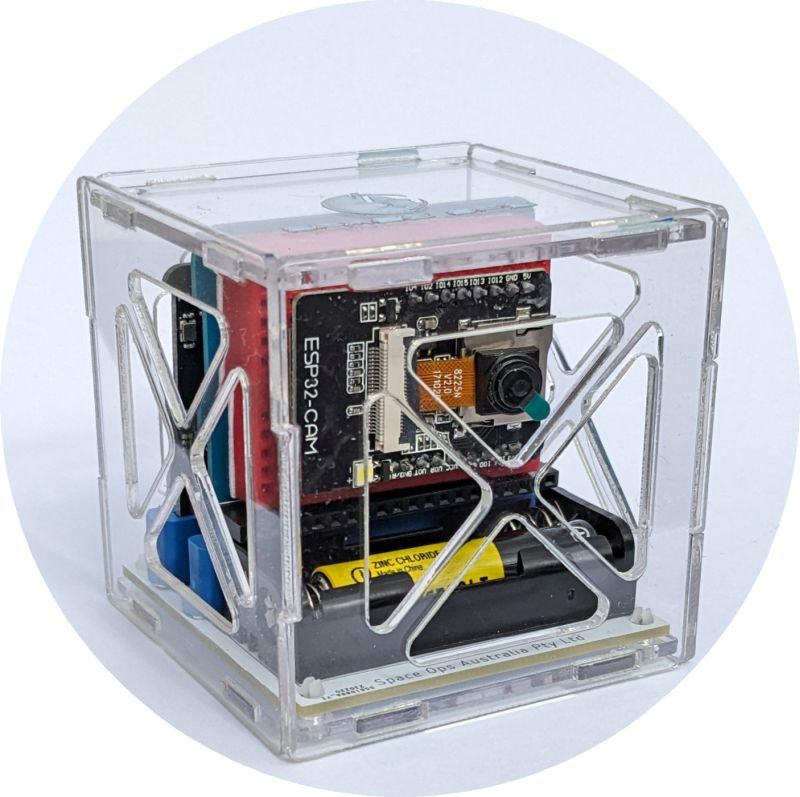
A month ago I had the opportunity to teach at the Vandenberg STARBASE. Now I must warn you I am not a teacher but an electronics engineer with years of experience developing medical electronics. I started my preparation by picking a hands-on topic that related to Vandenberg. I decided on SmallSats since some Vandenberg-launched missions include SmallSats as piggyback payloads. Knowing that I was going to teach two combined classes totaling 40-50 students, I bought four Space Ops Australia educational picosat kits, a two-pack of ESP32-CAM Wi-Fi based camera modules, and a ten-pack of BBC Micro: Bit computer kits. Each picosat kit includes the plastic housing, BBC Micro: Bit computer board, sensor board, and breadboard.
The Wi-Fi based ESP32-CAM was attached to the breadboard and was used to transmit images. The light, gyro and magnetic compass sensors contained on the BBC board were used instead of the separate sensor board. The next step was for me to code the complete satellite project using the free Microsoft MakeCode development software. The nice thing about MakeCode is that students can start learning to code using the simple graphical block editor and then click a tab to see the same program in the JavaScript programming language. As they gain more experience they can program in JavaScript, which is a widely used higher level programming language.
My plan was to divide the students up into ten groups of five or less students. Doing so would allow for more hands-on time for each student. Just like commercial products are created using teams such as the marketing, research, development, and manufacturing teams, I wanted each group to learn about a unique part of our overall picosat mission. The following teams were created, a lesson plan for each team was written and the overall code was broken into smaller modules for each team to learn.
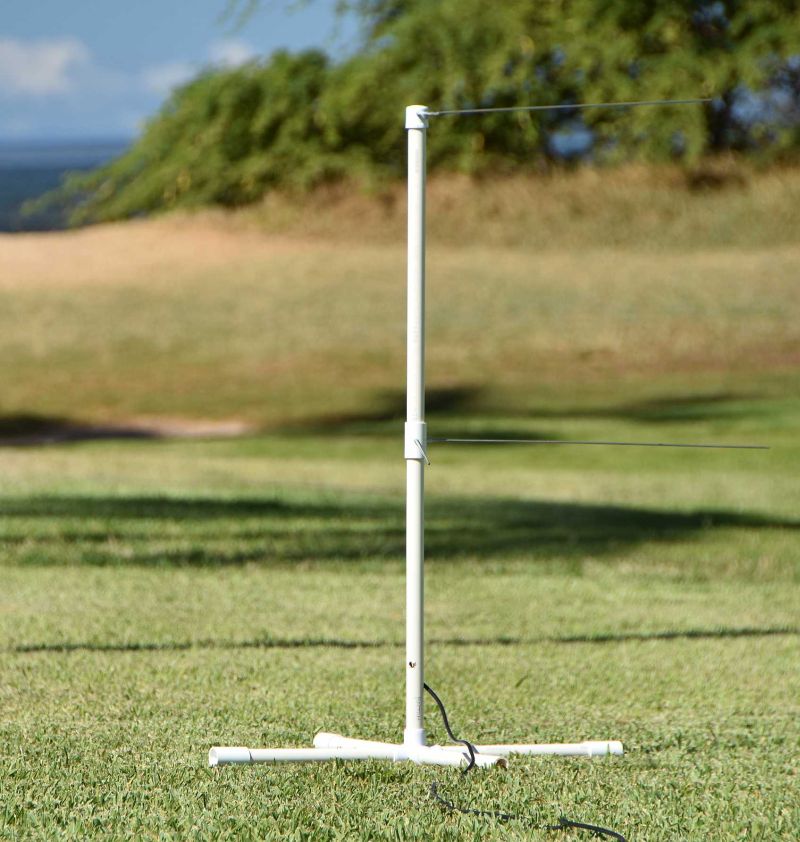
As an added project, I built a portable weather satellite antenna using ½" PVC pipe and four metal rods, and took it on my Hawaiian vacation to test. Knowing it worked well and that there would be a satellite pass over Vandenberg during the class, I took it to demo.
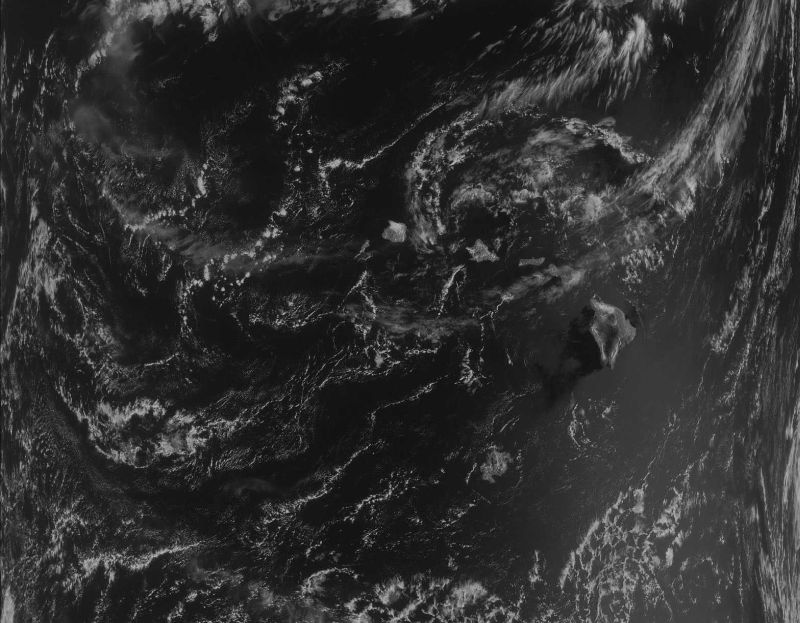
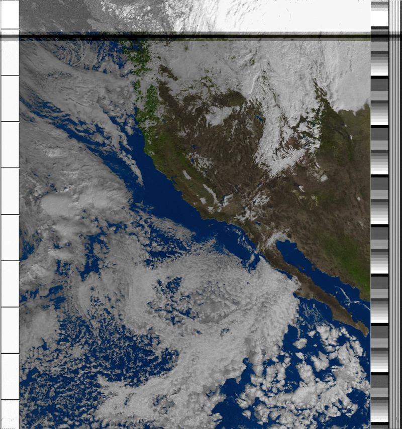
The big day came, the students were excited, and I was nervous, but fortunately things went according to plan with only a few minor glitches. Class started with a brief introduction, and then the students were off following the lesson plans with a lot of help from the many volunteers, while I floated around helping where I could. Before I knew it the hour passed and it was time to see what the students had learned. But before we did, the satellite passed overheard, and because it was the older analog satellite, the class got to not only see the image being received and displayed, but also they got to hear it as well.
A good friend of mine recommended to give each student in a group a unique role such as facilitator, recorder, presenter, checker and timekeeper, for better engagement. The presenter from each group was called up, one at a time, to explain to the class what they learned and to demo their BBC board. In the case of one shy presenter, the rest of her team was asked to come up and support her. Towards the end, the assembly team assembled the satellite, the transmitter team exercised the sensors, while the receiver team showed the data being received and displayed on the big projection screen. After a round of applause, the mission patch stickers were distributed and the students asked me questions ranging from what I do at work to what I love about engineering.
If you ever thought of sharing your skills with eager students who want to learn, don’t hesitate to contact STARBASE at https://dodstarbase.org/contact/. You will be glad you did.
A big thank you to the STARBASE teachers for allowing me to participate and a special thank you to the many volunteers who helped the students.
[ Back to Top ]


By Laura Snider, NCAR & UCAR News
at https://news.ucar.edu/132917/scientists-gain-powerful-tool-scrutinize-changing-us-weather-patterns
October 6, 2023
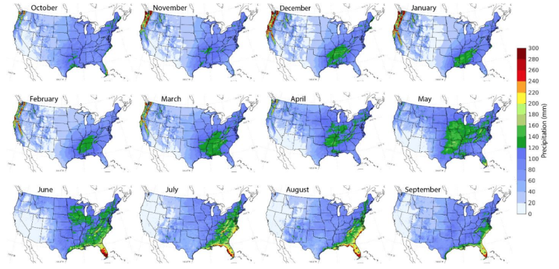
An extraordinary new dataset of high-resolution weather simulations that span more than four decades over the continental United States is now available to the Earth system science community.
The unprecedented resource — which required almost a year's worth of supercomputing time to create and is nearly one petabyte in size — provides rich opportunities for scientists and stakeholders interested in how weather patterns may have already shifted as the climate warms, among many other applications. For example, scientists are already using the data to dig into new techniques for improving long-range forecasting, planning for water resource allocation, and to better understand the causes and impacts of extreme and rare weather events.
The dataset, known as CONUS404, is the result of a collaboration between the National Center for Atmospheric Research (NCAR) and the U.S. Geological Survey (USGS).
"To study rare and extreme weather events that we are really interested in, you need decades worth of data and that data need to be at high resolution," said Roy Rasmussen, the NCAR senior scientist who led the project. "With CONUS404 it is possible to study both long-term events that can stretch for many years, like droughts, and rare events that don’t last long but rarely occur, like extreme floods."
CONUS404 was funded by the USGS and the U.S. National Science Foundation, which is NCAR's sponsor.
See also NOAA's GeoPlatform at https://noaa.maps.arcgis.com/home/index.html and NOAA Unveils New Tool for Exploring Coral Reef Data at https://www.noaa.gov/news-release/noaa-unveils-new-tool-for-exploring-coral-reef-data.
[ Back to Top ]
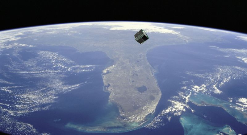
By Monica Luabeya, NASA
at https://www.nasa.gov/image-article/the-beginnings-of-a-sunrise/
November 29, 2023

City lights stretch across the United States like a string of holiday lights in this image taken from the International Space Station on Nov. 10, 2023. At far left, the lights of Chicago, Illinois, are outlined by Lake Michigan. At far right, the Dallas/Fort Worth metropolitan area shines through the clouds while the sun’s first rays start to light up Earth’s atmosphere (at top).
Since the space station became operational in November 2000, crew members have produced hundreds of thousands of images of the land, oceans, and atmosphere of Earth. Their photographs of Earth record how the planet changes over time due to human activity and natural events. This allows scientists to monitor disasters and direct response on the ground and study phenomena, from the movement of glaciers to urban wildlife.
Explore more images of cities at night taken by astronauts on the space station.
[ Back to Top ]


From NOAA News & Features
at https://www.noaa.gov/news-release/2023-ozone-hole-ranks-12th-largest-on-record
November 1, 2023
UPDATED: November 1, 2023. Correction: The original version of this story misstated the ranking of the 2023 ozone hole. It was the 12th largest single-day hole on record, and the 16th largest when averaged from September 7 to October 13.
The 2023 Antarctic ozone hole reached its maximum size at 10 million square miles (26 million square kilometers) on September 21, which ranks as the 12th largest since 1979, according to annual satellite and balloon-based measurements made by NOAA and NASA.
During the peak of the ozone depletion season from September 7 to October 13, the hole this year averaged 8.9 million square miles (23.1 million square kilometers), approximately the size of North America.
"It’s a very modest ozone hole," said Paul Newman, leader of NASA's ozone research team and chief scientist for Earth sciences at NASA's Goddard Space Flight Center in Greenbelt, Maryland. "Declining levels of human-produced chlorine compounds, along with help from active Antarctic stratospheric weather slightly improved ozone levels this year."
The ozone layer acts like Earth’s natural sunscreen, as this portion of the stratosphere shields our planet from the sun’s harmful ultraviolet (UV) radiation. A thinning ozone layer means less protection from UV rays, which can cause sunburns, cataracts and skin cancer in humans.
[ Back to Top ]
From NOAA News & Features
at https://www.noaa.gov/news/mississippi-river-hit-record-low-levels-in-october
November 8, 2023
A relatively warm October and expanding drought conditions across the Lower Mississippi Valley helped drop water levels to historic lows along parts of the Mississippi River last month.
The U.S. also confirmed another billion-dollar disaster in October, bringing the total to a record 25 disasters in the first 10 months — the largest number of disasters for any year since NOAA has kept track of these types of events.
Here are more highlights from NOAA’s latest monthly U.S. climate report
See also Topping the Charts: September 2023 Was Earth's Warmest September in 174-Year Record at https://www.noaa.gov/news/topping-charts-september-2023-was-earths-warmest-september-in-174-year-record and
[ Back to Top ]


The next four Apply articles specifically highlight information about Climate Change and El Niño, two topic areas important enough to rate their own banners.

By Dana Nuccitelli, Yale Climate Connections
at https://yaleclimateconnections.org/2023/11/eight-key-takeaways-from-the-new-national-climate-assessment/
November 20, 2023
The U.S. has made progress in reducing heat-trapping carbon pollution, but extreme weather caused by climate change is harming U.S. residents in every region, according to the National Climate Assessment released in November 2023.
Here are eight things to know about the report.
See also Climate Change Impacts are Increasing for Americans at https://www.noaa.gov/news-release/climate-change-impacts-are-increasing-for-americans and See SWOT Mission's Unprecedented View of Global Sea Levels at https://www.jpl.nasa.gov/news/see-swot-missions-unprecedented-view-of-global-sea-levels.
[ Back to Top ]
From NOAA News & Features
at https://www.noaa.gov/news-release/biden-harris-administration-releases-greenhouse-gas-monitoring-strategy
November 29, 2023
Today, the Biden-Harris Administration released a conceptual framework for a national system to measure, monitor and share information related to reducing greenhouse gas emissions in order to meet U.S. commitments under the 2015 Paris Agreement.
Led by the White House Office of Management and Budget, Office of Science and Technology Policy, and Climate Policy Office, the new U.S. Greenhouse Gas Measurement, Monitoring, and Information System strategy builds on a wide array of cooperative research, data products, activities and capabilities aimed at understanding emissions, removals and sinks of greenhouse gases (GHGs) from national to regional and urban scales as well as from a range of sources.
NOAA will commit its long-established, state-of-the-art capabilities in observation, modeling and data analysis, including the Global Greenhouse Gas Reference Network, Carbon Tracker, HYSPLIT dispersion model and satellite remote sensors, to support this whole-of-government effort.
"NOAA’s more than 50 years of measuring and monitoring greenhouse gas emissions around the globe provide a solid foundation for this new national effort to better understand the main driver of climate change," said NOAA Administrator Rick Spinrad, PhD. "Our contributions reflect NOAA's critical role in observing, predicting and sharing this knowledge with communities to help them build resilience to the effects of climate change."
Identifying and quantifying emissions of the major greenhouse gases — carbon dioxide (CO2), methane (CH4) and nitrous oxide (N2O) — emitted by human activity as well as terrestrial and aquatic landscapes, is a complex challenge that requires direct and indirect measurements, modeling efforts and collection of data across a variety of sectors and systems. Some sources, such as fossil fuel CO2 emissions, can be estimated with high accuracy. Sources of methane emissions, which range from fossil fuel use, to agriculture, livestock, landfills and wetlands, are more variable and make estimates challenging.
See also NASA Mission Excels at Spotting Greenhouse Gas Emission Sources at and NASA Flights Link Methane Plumes to Tundra Fires in Western Alaska at
[ Back to Top ]


From NASA Jet Propulsion Laboratory
at https://www.jpl.nasa.gov/news/nasa-analysis-finds-strong-el-nino-could-bring-extra-floods-this-winter
November 8, 2023
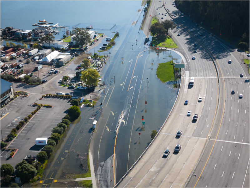
Such high-tide flooding that inundates roads and buildings along the west coast of the Americas tends to be uncommon outside of El Niño years, but that could change by the 2030s.
An analysis by NASA's sea level change science team finds that if a strong El Niño develops this winter, cities along the western coasts of the Americas could see an increase in the frequency of high-tide flooding that can swamp roads and spill into low-lying buildings.
El Niño is a periodic climate phenomenon characterized by higher-than-normal sea levels and warmer-than-average ocean temperatures along the equatorial Pacific. These conditions can spread poleward along the western coasts of the Americas. El Niño, which is still developing this year, can bring more rain than usual to the U.S. Southwest and drought to countries in the western Pacific like Indonesia. These impacts typically occur in January through March.
The NASA analysis finds that a strong El Niño could result in up to five instances of a type of flooding called a 10-year flood event this winter in cities including Seattle and San Diego. Places like La Libertad and Baltra in Ecuador could get up to three of these 10-year flood events this winter. This type of flooding doesn't normally occur along the west coast of the Americas outside of El Niño years. The researchers note that by the 2030s, rising seas and climate change could result in these cities experiencing similar numbers of 10-year floods annually, with no El Niño required.
[ Back to Top ]
By Rebecca Lindsy and Brian Brettschneider, Reviewed by Michelle L'Heureux, Nat Johnson, Emily Becker, Climate.gov
at https://www.climate.gov/news-features/featured-images/historically-how-has-el-nino-influenced-summer-temperature-and
August 24, 2023
Ever since NOAA declared El Niño to be officially underway in June 2023, people have been asking us what it would mean for summer heat. For most of the United States, the short answer has been "probably very little." Or as the experts put it, El Niño doesn't have a strong summer climate signal for most of the country. That's true whether we look at departures from average temperature (anomalies) in summers leading up to El Niño, or whether we look at the frequency of warmer-than-average summers, which is what we are showing here.
For parts of the tropics, it’s a different story. Northern Hemisphere summers that lead up to El Niño winters do tend to be hotter than average across parts of northern Africa, India, and Central and South America. They also tend to be drier than average.
Exactly how often do these patterns occur? These maps show the scorecard for all 29 El Niño summers on record, 1950–present. For this analysis, which was done by Brian Brettschneider, a climate expert with the National Weather Service-Alaska, what we are calling an "El Niño summer" is any summer (June-August) leading into a winter (December-February) with El Niño conditions, regardless of whether El Niño was officially in place in the summer. (See "additional details" for an explanation of why Brettschneider chose to look at things this way.)
See also Watch La Niña Fade and El Niño Approach in the Tropical Pacific Ocean in 2023 at https://www.climate.gov/news-features/featured-images/watch-la-ni%C3%B1a-fade-and-el-ni%C3%B1o-approach-tropical-pacific-ocean-2023.
[ Back to Top ]

From NOAA News & Features at https://www.noaa.gov/news-release/noaa-21-satellite-is-now-operational
November 8, 2023
It's official: NOAA-21, the latest satellite in NOAA's Joint Polar Satellite System, is operational.
The satellite joins its predecessors, Suomi NPP and NOAA-20, each circling the globe 14 times a day, providing a continuous stream of data to improve the accuracy of NOAA's 3–7 day forecasts. This includes observations for extreme weather events and monitoring climate change.
The satellite launched in November 2022 as JPSS-2 was renamed NOAA-21 when it reached orbit. NOAA-21 now gives NOAA three spacecraft operating the most sophisticated technology the agency has ever flown in a polar orbit, capturing precise observations of the world's atmosphere, land and waters.
"NOAA-21 will help generate improved, reliable forecasts that can save lives, protect property and provide communities and decision makers with the critical time needed to prepare for dangerous weather events," said Michael C. Morgan, Ph.D., assistant secretary of commerce for environmental observation and prediction.
NOAA-21 provides NOAA's National Weather Service with global data for the numerical weather prediction models used to develop timely and accurate U.S. weather forecasts. In addition, high-resolution imagery from the satellite's Visible Infrared Imaging Radiometer Suite, known as VIIRS, will enable NOAA-21 to detect fog, Arctic sea ice, volcanic eruptions and wildfires.
[ Back to Top ]
From NASA Jet Propulsion Laboratory
at https://www.jpl.nasa.gov/news/nasa-uses-two-worlds-to-test-future-mars-helicopter-designs
November 22, 2023
For the first time in history, two planets have been home to testing future aircraft designs. On this world, a new rotor that could be used with next-generation Mars helicopters was recently tested at NASA’s Jet Propulsion Laboratory in Southern California, spinning at near-supersonic speeds (0.95 Mach). Meanwhile, the agency’s Ingenuity Mars Helicopter has achieved new altitude and airspeed records on the Red Planet in the name of experimental flight testing.
"Our next-generation Mars helicopter testing has literally had the best of both worlds," said Teddy Tzanetos, Ingenuity's project manager and manager for the Mars Sample Recovery Helicopters. "Here on Earth, you have all the instrumentation and hands-on immediacy you could hope for while testing new aircraft components. On Mars, you have the real off-world conditions you could never truly re-create here on Earth." That includes a whisper-thin atmosphere and significantly less gravity than on Earth.
The next-generation carbon fiber rotor blades being tested on Earth are almost 4 inches (more than 10 centimeters) longer than Ingenuity’s, with greater strength and a different design. NASA thinks these blades could enable bigger, more capable Mars helicopters. The challenge is, as the blade tips approach supersonic speeds, vibration-causing turbulence can quickly get out of hand.
[ Back to Top ]

From NASA Jet Propulsion Laboratory
at https://www.nasa.gov/missions/odyssey/nasa-orbiter-snaps-stunning-views-of-mars-horizon/
November 28, 2023
Astronauts often react with awe when they see the curvature of the Earth below the International Space Station. Now Mars scientists are getting a taste of what that’s like, thanks to NASA’s 2001 Mars Odyssey orbiter, which completed its 22nd year at the Red Planet last month.
The spacecraft captured a series of panoramic images that showcases the curving Martian landscape below gauzy layers of clouds and dust. Stitched end to end, the 10 images offer not only a fresh, and stunning, view of Mars, but also one that will help scientists gain new insights into the Martian atmosphere.
The spacecraft took the images in May from an altitude of about 250 miles (400 kilometers) – the same altitude at which the space station flies above Earth.
"If there were astronauts in orbit over Mars, this is the perspective they would have," said Jonathon Hill of Arizona State University, operations lead for Odyssey’s camera, called the Thermal Emission Imaging System, or THEMIS. "No Mars spacecraft has ever had this kind of view before."
[ Back to Top ]
From NASA Science Editorial Team
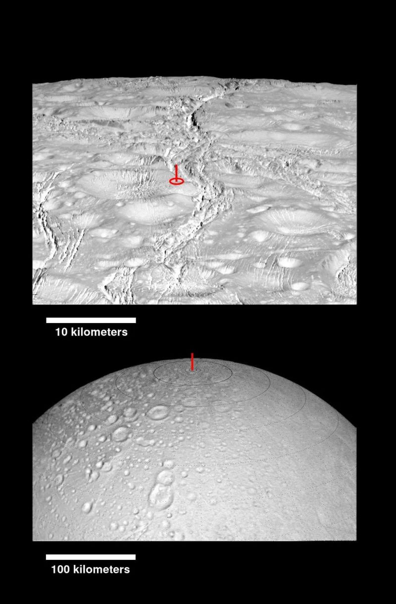
at https://science.nasa.gov/missions/cassini/cassini-10-years-at-saturn-top-images/
November 27, 2023
The Cassini team is proud to celebrate 10 years since arriving at Saturn with this collection of images selected by members of the team.
HINT: The link below each image provides detailed description of the image and its importance.
[ Back to Top ]
From NASA
at https://www.nasa.gov/event/nasas-europa-clipper/
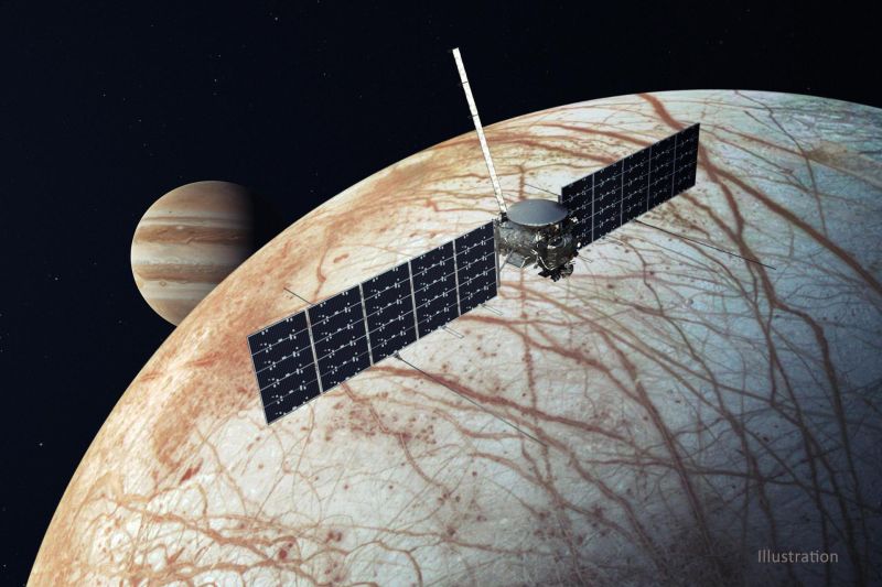
NASA's Europa Clipper will investigate Jupiter’s moon Europa to determine whether there are places below Jupiter’s icy moon, Europa, that could support life. The mission’s detailed investigation of Europa will help scientists better understand the astrobiological potential for habitable worlds beyond our planet.
Join the mission and have your name stenciled on a microchip that will be attached to the spacecraft as it travels 1.8 billion miles to explore Europa. Sign up to send your name on NASA’s Europa Clipper spacecraft by Sunday, Dec. 31.
[ Back to Top ]


From NOAA Fisheries
at https://www.fisheries.noaa.gov/feature-story/new-funding-opportunities-support-k-12-environmental-literacy-state-wide-environmental
November 7, 2023
People who are environmentally literate can be effective workers and problem solvers as well as thoughtful community leaders and participants. The Chesapeake Bay Watershed Education and Training program helps students in the Chesapeake Bay watershed become environmentally literate.
NOAA Fisheries has announced two funding opportunities that will support outstanding projects through Chesapeake B-WET this year. These projects provide hands-on environmental education about issues affecting the Bay watershed through meaningful watershed educational experiences for all students in a given school district or even state. These experiences also support professional development for K-12 educators. In addition, NOAA Fisheries also aims to support state-wide efforts.
[ Back to Top ]
By Jessica Gwinn, NOAA Global Ocean Monitoring & Observations (GOMO)
at https://globalocean.noaa.gov/new-education-resource-keeping-an-eye-on-earths-oceans-with-argo-robots/
October 17, 2023

A new article was released in the Earth Sciences section of the journal Frontiers for Young Minds. "Keeping An Eye On Earth’s Oceans With Argo Robots," describes the technology, applications, and developments of Argo floats, a major component of the Global Ocean Observing System, and provides a kid-friendly introduction to topics like ocean observing and climate change. The article features colorful diagrams and infographics that illustrate Argo float anatomy and explain how Argo data are used to inform ocean and climate forecasting, adaptation, policy and management. Students are also invited to track their own float with the Adopt a Float program, a free educational program allowing classes to explore the ocean by following the progress of their float and accessing its data, or to learn more through resources like the Argo Online School and Ocean Observers platform.
[ Back to Top ]
By Melissa L. Gaskill, NASA
at https://www.nasa.gov/missions/station/iss-research/ham-radio-in-space-engaging-with-students-worldwide-for-40-years/
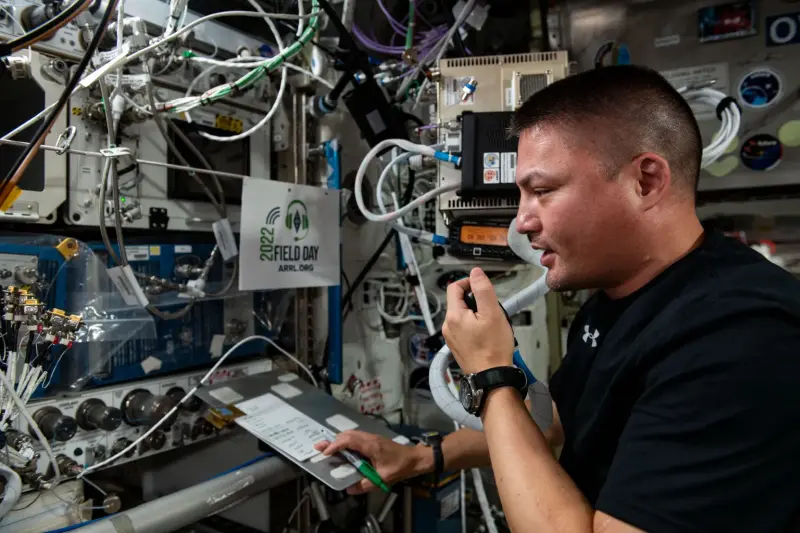
In May 2018, a student at Mill Springs Academy in Alpharetta, Georgia, Andrew Maichle, talked to NASA astronaut Scott Tingle on the International Space Station via amateur or ham radio. The experience profoundly affected Maichle, who went on to study electrical engineering at Clemson University in South Carolina.
"It was so cool to see in real time the utmost levels of what people in science are able to accomplish, and to talk to and interact with someone at that level," Maichle recalls. "The space station is an incredible work of engineering and to interact with someone in space was just mind-boggling. I was extraordinarily honored and very lucky to have had the opportunity."
[ Back to Top ]
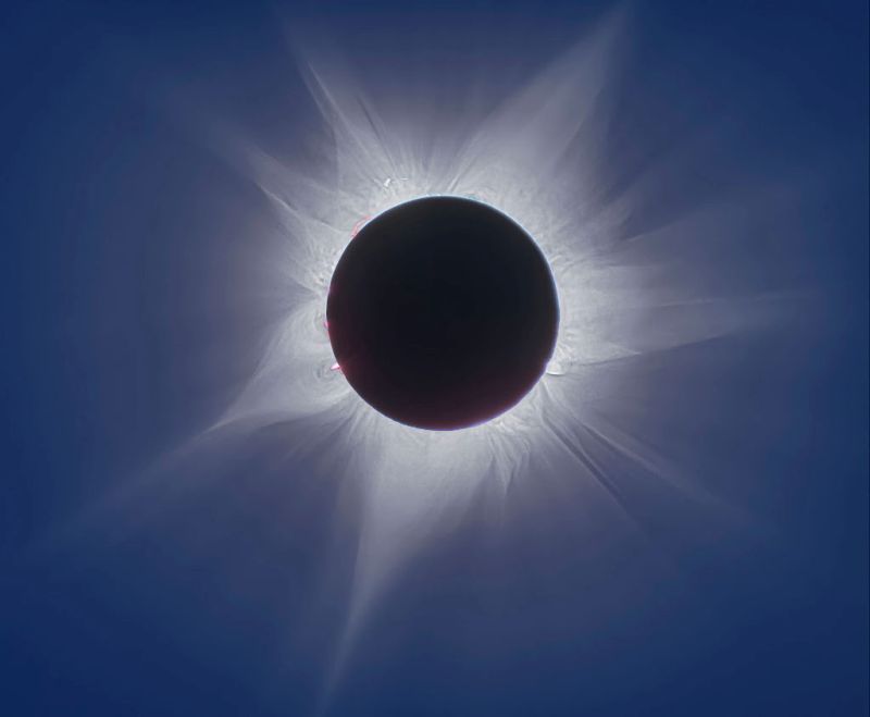
The National Science Teaching Association (NSTA) in collaboration with the Space Science Institute (SSI) seeks up to 100 educators of science to provide learning resources and information to their schools, local libraries and/or community organizations about the Monday, April 8, 2024, total eclipse. We know many of you remember the excitement and beauty of the 2017 total solar eclipse, so this is an opportunity to help people in your community make the most of the last total solar eclipse visible in the continental US until 2045.
[ Back to Top ]


During my pre- and early teen years, I would sometimes accompany my father as he drove across the Los Angeles basin on business. The typical trip went from the far northeast corner of Los Angeles to the west side near Santa Monica. Many of the freeways that are so used and crowded today did not yet exist. As we travelled city streets he often remarked that this or that office building had not been there twenty years earlier; it had been a coffee shop or a strawberry field or simply an empty lot. I remember thinking how unique to have memory of the area reaching that far back. As my own children were growing up, I found myself similarly remarking about changes in our area over the previous twenty years. Greek philosopher Heraclitus (c.500 BCE) is credited with the saying, 'Nothing endures but change.' In other words, the only constant in the universe is change. Just how has the area in which we live changed over a generation or more? Is there more or less vegetation? Has the number or type of buildings changed? Are there new streets and highways? How is the land being used? How do changes in land use affect the human population and the overall health of the planet? How do human activities and choices affect the quality and type of land cover? Can land cover and land use be measured on a large scale? Are such changes related in any way to global climate change? This lesson will introduce the learner to normalized difference vegetative index imagery. The learner will access and analyze multispectral satellite imagery especially prepared to indicate the amount and productivity of vegetative land cover and thus follow changes over a number of years.
| Grade Level: | 9-12 |
| Time Requirement: | 2-3 class periods |
| Prerequisites: | None |
| Relevant Disciplines: | Physical, Life, Earth & Space Sciences, Geography |
[ Back to Top ]
Share your satellite-based lesson ideas with the teaching community.
Send us a full lesson plan, or simply suggest a lesson idea. If you found the idea online, please share the source as well. The lesson can be about anything that helps connect learners with satellite-based technology - any grade level K-12 - any STEM subject area or geography.
"Satellite-technology" includes any part of the science, math, engineering, or technology of satellites, rockets, and remote sensing instruments as well as the use of any environmental satellite data to explore questions related to aspects of global change and local impacts in the long term, short term, and catastrophic time frames. Of special interest are lessons providing opportunities for learners to inquire, experiment, and apply mathematics.
Perhaps you designed a lesson yourself - we will happily prepare it for future publication in More Lessons from the Sky and inclusion in the SEA Lesson Plan Library. Perhaps you found a worthy lesson plan published elsewhere - we can research it inclusion in a lesson plan spotlight. In either case, you will receive full credit for developing and/or bringing the lesson to the attention of the teaching community. Don't forget to share your insights if you tried the lesson with students.
Please share your ideas at SEA.Newsletter@SatEd.org.
[ Back to Top ]
![]()

This edition of the SEA Newsletter was produced in HTML5.
It is best viewed with most recent updates of Firefox, Edge, Chrome, Opera, or Safari.
©Satellite Educators Association, Inc. https://SatEd.org SEA.Newsletter@SatEd.org
Satellite Educators Association, Inc. is a 501(c)(3) non-profit educational organization.
In 2023, the SEA Newsletter changed from monthly to quarterly publication (March, June, September, and December). The SEA Newsletter is published on-line and available at no cost.
SEA terms, conditions, policies, and contact information are detailed HERE.
Unless otherwise listed, all photo and image credits are the authors of the articles.
Any opinons expressed in this Newsletter are those of the authors
and not necessarily those of the Satellite Educators Association, Inc.
or any of its officers, members, or representatives.
Many SEA Newsletter items contain third-party links to sites not governed by Satellite
Educators Association, Inc. The viewer is cautioned to be aware of the terms of use and
privacy policies for those third-party sites.
![]()